IMAGES TAKEN NEAR TO
BEAMINSTER, DT8 3PP
Introduction
This page details the photographs taken nearby to DT8 3PP by members of the Geograph project.
The Geograph project started in 2005 with the aim of publishing, organising and preserving representative images for every square kilometre of Great Britain, Ireland and the Isle of Man.

There are currently over 7.5m images from over14,400 individuals and you can help contribute to the project by visiting https://www.geograph.org.uk
Image Map (Loading...)


Getting Data...Please wait
Leaflet Map data © OpenStreetMap
Images are licensed for reuse under creativecommons.org/licenses/by-sa/2.0
Notes
- Clicking on the map will re-center to the selected point.
- The higher the marker number, the further away the image location is from the centre of the postcode.
Image Listing (13 Images Found)
Images are licensed for reuse under creativecommons.org/licenses/by-sa/2.0
Image
Details
Distance
1
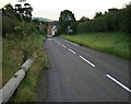
Entering Beaminster on the B3163
Looking east along the B3163. The entrance to Clipper Teas is just visible in the distance.
Image: © Les Mildon
Taken: 17 Aug 2007
0.07 miles
2
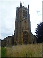
St. Mary's Church Beaminster
Fine old church tower with wildlife friendly church yard
Image: © Michael Graham
Taken: 24 Aug 2013
0.09 miles
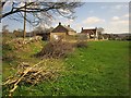
3

Wessex Ridgeway approaching Beaminster
The last field, crossed by footpath W21/66, before the built-up area. On the extreme left is the Clipper Teas factory with a green storage lorry outside.
Image: © Derek Harper
Taken: 13 Apr 2014
0.09 miles
4

Wessex Ridgeway leaving Beaminster
A reverse view of Image taken from the far corner of the field, looking up footpath W21/66 towards Higher Barrowfield Farm.
Image: © Derek Harper
Taken: 13 Apr 2014
0.10 miles
5

Half Acre Lane, Beaminster
Also the route of footpath W21/91 and the Wessex Ridgeway.
Image: © Derek Harper
Taken: 13 Apr 2014
0.13 miles
6
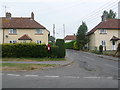
Beaminster: postbox № DT8 96, Broadwindsor Road
The easternmost of the town's seven postboxes, this one is on the corner of Eggardon Close and is emptied finally at 4:45pm on weekdays and at 9:30am on Saturdays.
Image: © Chris Downer
Taken: 2 Jul 2009
0.15 miles
7
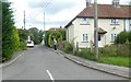
Eggardon Close, Beaminster
One of several residential roads to the west of the centre of Beaminster
Image: © David Smith
Taken: 20 Aug 2019
0.15 miles
8
Brushwood, Beaminster
The Wessex Ridgeway crosses this narrow grass field behind houses on the B3163 Clay Lane, following footpath W21/67 past a newly-laid hedge.
Image: © Derek Harper
Taken: 13 Apr 2014
0.20 miles
9
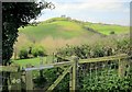
Wessex Ridgeway at the Stoke Water valley
A gate on the descent from Higher Barrowfield Farm on footpath W21/66. The Ridgeway then climbs Gerrard's Hill in the background.
Image: © Derek Harper
Taken: 13 Apr 2014
0.21 miles
10

Willow catkins, Beaminster
Alongside a tributary of the Brit, at the edge of a meadow crossed by the Wessex Ridgeway.
Image: © Derek Harper
Taken: 13 Apr 2014
0.21 miles