IMAGES TAKEN NEAR TO
Whitcombe Road, BEAMINSTER, DT8 3NW
Introduction
This page details the photographs taken nearby to Whitcombe Road, DT8 3NW by members of the Geograph project.
The Geograph project started in 2005 with the aim of publishing, organising and preserving representative images for every square kilometre of Great Britain, Ireland and the Isle of Man.

There are currently over 7.5m images from over14,400 individuals and you can help contribute to the project by visiting https://www.geograph.org.uk
Image Map (Loading...)


Getting Data...Please wait
Leaflet Map data © OpenStreetMap
Images are licensed for reuse under creativecommons.org/licenses/by-sa/2.0
Notes
- Clicking on the map will re-center to the selected point.
- The higher the marker number, the further away the image location is from the centre of the postcode.
Image Listing (8 Images Found)
Images are licensed for reuse under creativecommons.org/licenses/by-sa/2.0
Image
Details
Distance
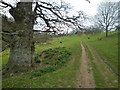
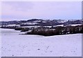
2
Track down into Storridge Farm
Looking down to the farm, and beyond to Beaminster beyond it in the misty valley.
Image: © Val Ghose
Taken: 17 Feb 2007
0.11 miles
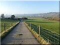
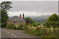
4
View North from Storridge Hill
Taken from the B3163 which runs from Beaminster to Toller Down Gate on the A356. The hill in the distance is White Sheet Hill.
Image: © Nigel Mykura
Taken: 26 Dec 2010
0.16 miles
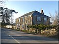
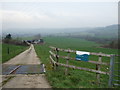
6
Storridge Hill Cottage
Beaminster can be seen in the background.
Image: © Ian Capper
Taken: 15 Jul 2008
0.19 miles
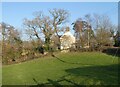
7
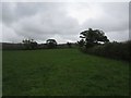
Footpath through field near Storridge Farm
Image: © Becky Williamson
Taken: 30 Sep 2017
0.23 miles