IMAGES TAKEN NEAR TO
South Perrott, BEAMINSTER, DT8 3HS
Introduction
This page details the photographs taken nearby to DT8 3HS by members of the Geograph project.
The Geograph project started in 2005 with the aim of publishing, organising and preserving representative images for every square kilometre of Great Britain, Ireland and the Isle of Man.

There are currently over 7.5m images from over14,400 individuals and you can help contribute to the project by visiting https://www.geograph.org.uk
Image Map (Loading...)


Getting Data...Please wait
Leaflet Map data © OpenStreetMap
Images are licensed for reuse under creativecommons.org/licenses/by-sa/2.0
Notes
- Clicking on the map will re-center to the selected point.
- The higher the marker number, the further away the image location is from the centre of the postcode.
Image Listing (79 Images Found)
Images are licensed for reuse under creativecommons.org/licenses/by-sa/2.0
Image
Details
Distance
1
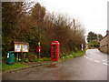
South Perrott: postbox № DT8 100 and phone
These red amenities stand alongside the parish noticeboard at a bus stop. The postbox is emptied finally at 4:15pm on weekdays and at 8:15am on Saturdays.
Image: © Chris Downer
Taken: 3 Apr 2010
0.02 miles
2
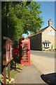
Communications, South Perrott
The village noticeboard, a postbox, and a telephone kiosk by the parking area opposite the Coach and Horses (right) across the A356.
Image: © Derek Harper
Taken: 26 May 2017
0.03 miles
3
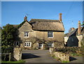
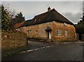
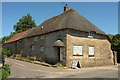
Thatched house - South Perrott
This house is situated on the main road opposite Church Hill.
Image: © Sarah Smith
Taken: 21 Feb 2009
0.04 miles
4
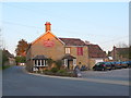
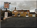
Coach and Horses South Perrott
This village gets its name from the River Parrett which rises in the hills nearby. This village pub is on the A356, the main road from Dorchester to Crewkerne that passes through the centre of the village.
Image: © Nigel Mykura
Taken: 2 May 2013
0.04 miles
5
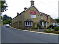
Cornerways, South Perrott
The house, seen here across the A356, is also shown at Image "Cottage, coach-house and stable, in one range. C18" https://historicengland.org.uk/listing/the-list/list-entry/1211874 .
Image: © Derek Harper
Taken: 26 May 2017
0.04 miles
6
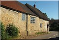
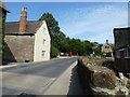
House, South Perrott
The building is listed and described at http://www.imagesofengland.org.uk/Details/Default.aspx?id=396420&mode=adv : "Various unmatching windows". School Hill meets the A356 on the right.
Image: © Derek Harper
Taken: 26 May 2017
0.04 miles