IMAGES TAKEN NEAR TO
South Perrott, BEAMINSTER, DT8 3HR
Introduction
This page details the photographs taken nearby to DT8 3HR by members of the Geograph project.
The Geograph project started in 2005 with the aim of publishing, organising and preserving representative images for every square kilometre of Great Britain, Ireland and the Isle of Man.

There are currently over 7.5m images from over14,400 individuals and you can help contribute to the project by visiting https://www.geograph.org.uk
Image Map (Loading...)


Getting Data...Please wait
Leaflet Map data © OpenStreetMap
Images are licensed for reuse under creativecommons.org/licenses/by-sa/2.0
Notes
- Clicking on the map will re-center to the selected point.
- The higher the marker number, the further away the image location is from the centre of the postcode.
Image Listing (73 Images Found)
Images are licensed for reuse under creativecommons.org/licenses/by-sa/2.0
Image
Details
Distance
2
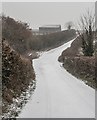
Lecher Lane near Tumberlands
On the day the snow fell.
Image: © Becky Williamson
Taken: 1 Mar 2018
0.04 miles
3
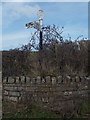
South Perrott: signpost at the Mosterton turn
This signpost is a bit of an oddity - it has one of the Dorset roundels on top, which normally gives location and grid reference, but is blank apart from the word DORSET around the top.
See Image for a close-up of the roundel and Image for an example of one with all the usual details.
Image: © Chris Downer
Taken: 10 Mar 2015
0.11 miles
4
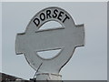
South Perrott: detail of a blank Dorset signpost
Looking up at the finial of Image], which would ordinarily have the location name across the middle and the grid reference around the bottom. For some reason, this one has been erected without these details added.
See Image for an example of a more usual one with all the details.
Image: © Chris Downer
Taken: 10 Mar 2015
0.11 miles
5
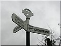
Old Direction Sign - Signpost by the A356, South Perrott
Annulus and bar finial - 3 arms; Dorset halo without NGR by the A356, in parish of South Perrott (West Dorset District), South Perrott, West of village at junction with UC road Lecher Lane.
Surveyed
Milestone Society National ID: DO_ST4706
Image: © Milestone Society
Taken: Unknown
0.12 miles
8
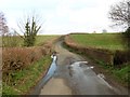
A356 at New Bridge
Hard to spot the bridge, which is over the Lecher Water, a tributary of the Parrett; it's near the willows on the right.
Image: © Derek Harper
Taken: 22 Apr 2015
0.17 miles