IMAGES TAKEN NEAR TO
Newtown, BEAMINSTER, DT8 3EP
Introduction
This page details the photographs taken nearby to Newtown, DT8 3EP by members of the Geograph project.
The Geograph project started in 2005 with the aim of publishing, organising and preserving representative images for every square kilometre of Great Britain, Ireland and the Isle of Man.

There are currently over 7.5m images from over14,400 individuals and you can help contribute to the project by visiting https://www.geograph.org.uk
Image Map (Loading...)


Getting Data...Please wait
Leaflet Map data © OpenStreetMap
Images are licensed for reuse under creativecommons.org/licenses/by-sa/2.0
Notes
- Clicking on the map will re-center to the selected point.
- The higher the marker number, the further away the image location is from the centre of the postcode.
Image Listing (33 Images Found)
Images are licensed for reuse under creativecommons.org/licenses/by-sa/2.0
Image
Details
Distance
1

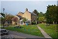
The Orange Way in Dorset and Somerset (68)
Here's a large school in Beaminster.
Image: © Shazz
Taken: 3 Jul 2012
0.04 miles
2
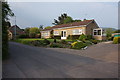
Sandhurst, Caretakers House at Beaminster School
Image: © Ian S
Taken: 28 May 2016
0.06 miles
4
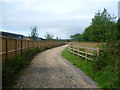
Outskirts of Beaminster
On a bridle path behind the newly built Primary School in Beaminster
Image: © Michael Graham
Taken: 25 Aug 2013
0.09 miles
5
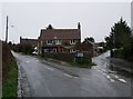
Junction of Chantry Lane and Bowgrove Road, Beaminster
The Wessex Ridgeway follows Bowgrove Road to the right
Image: © Tim Heaton
Taken: 29 Jan 2013
0.09 miles
6

The Orange Way in Dorset and Somerset (69)
This is Newtown with parking for the school on the left.
Image: © Shazz
Taken: 3 Jul 2012
0.09 miles
7
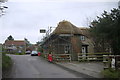
Newly Thatched Cottage. Beaminster
This cottage which appears to be a small semi-detached one sits close to the junction of Chantry Lane and Bowgrove Rd in Newtown, Beaminster. Chantry Lane is the road going off on the left.
Image: © Nigel Mykura
Taken: 5 Jan 2015
0.10 miles
9

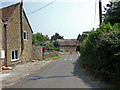
Chantry Lane, Newtown
A no through road passing Crooked Lane, carrying bridleway W21/74, on the left.
Image: © Derek Harper
Taken: 13 Apr 2014
0.11 miles
10

The Orange Way in Dorset and Somerset (70)
Take the left fork here up Chantry Lane.
Image: © Shazz
Taken: 3 Jul 2012
0.12 miles