IMAGES TAKEN NEAR TO
Hogshill Mead, BEAMINSTER, DT8 3DA
Introduction
This page details the photographs taken nearby to Hogshill Mead, DT8 3DA by members of the Geograph project.
The Geograph project started in 2005 with the aim of publishing, organising and preserving representative images for every square kilometre of Great Britain, Ireland and the Isle of Man.

There are currently over 7.5m images from over14,400 individuals and you can help contribute to the project by visiting https://www.geograph.org.uk
Image Map (Loading...)


Getting Data...Please wait
Leaflet Map data © OpenStreetMap
Images are licensed for reuse under creativecommons.org/licenses/by-sa/2.0
Notes
- Clicking on the map will re-center to the selected point.
- The higher the marker number, the further away the image location is from the centre of the postcode.
Image Listing (49 Images Found)
Images are licensed for reuse under creativecommons.org/licenses/by-sa/2.0
Image
Details
Distance
1
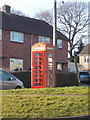
Beaminster: phone box in Clay Lane
Clay Lane seems to be the name of both the main road and the side turning which we see in the background.
Image: © Chris Downer
Taken: 10 Mar 2015
0.06 miles
2
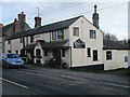
The Knapp Inn, for sale
Free House on Clay Lane for sale.
Image: © John Stephen
Taken: 16 Feb 2017
0.06 miles
3

Beaminster: postbox № DT8 45, Clay Lane
This George VI-reign postbox is emptied finally at 10 o'clock each weekday morning – the only box in the town not to have a late afternoon collection – and at 9am on Saturdays.
Image: © Chris Downer
Taken: 2 Jul 2009
0.06 miles
4

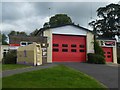
Beaminster fire station
Beaminster fire station, Clay Lane, Beaminster, is station 04 of the Dorset Fire & Rescue Service.
Image: © Kevin Hale
Taken: 10 Aug 2006
0.07 miles
6
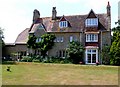
Thomas Hardy Locations: Tess of the D'Urbervilles
This is the Vicarage of Beaminster in Dorset which was the basis for the Vicarage of Emminster in Thomas Hardy's book Tess of the D'Urbervilles.
In the novel, Tess is raped by her cousin Alec Durberville. She marries her sweetheart Angel Clare but when he finds out that she is no longer a maiden, he abandons her and she becomes penniless. She decides to walk west across the Dorset downs to beg help from her father-in-law Mr. Clare, the vicar of Emminster who lived in the fictional version of this house.
She started her walk in the fictional village of Flintcombe Ash (based on the real village of Plush) which Hardy described as a "starve-acre place", where the poverty stricken Tess scraped a living grubbing turnips from the muddy fields nearby. And she walks the 17 mile to Emminster.
As it is so far to walk she can only do it on a Sunday and just as she arrives in Emminster she changes out of her rough walking boots and hides them in a hedge and puts on nice shoes to arrive at the vicarage. But she finds that everyone is at church and so she waits for her father in law to return. While waiting two young men, who turn out to be Angel Clare's brothers approach her from behind unaware of who she is. Tess overhears them talking about Angel and herself in derogatory terms. They also find her hidden boots and when the men meet Mercy Chant, Angel's former sweetheart, Mercy decides to give the boots to "some poor person".
Tess is totally disillusioned and doesn't go to the vicarage but carries on walking back along the road she came by. She reaches a village nearby and stops for lunch and learns a travelling preacher is in the barn she is passing. She hears the preachers voice and recognises it as Alec Durberville, who is testifying to having been converted by Mr. Clare.
She once again is on the road to falling under the spell of her evil cousin and subsequent ruin.
The actual vicarage was built in Broadwindsor Rd in 1859-61 to a design by William White. Pevsner describes it as Tough High Victorian Gothic "a rarity in Dorset". Part of the front of the building is occupied by an incongruous modern hair salon. This is the view from the rear lawn.
Thank you to the owner for giving me permission to take this photo.
Image: © Nigel Mykura
Taken: 30 Jun 2010
0.09 miles
7
The Wessex Ridgeway path entering the outskirts of Beaminster
Image: © Tim Heaton
Taken: 24 Jan 2017
0.09 miles
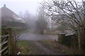
8

Meadow, Beaminster
Crossed from end to end by the Wessex Ridgeway following footpath W21/67, this long narrow field is between a tributary of the Brit and houses on the B3163 Clay Lane.
Image: © Derek Harper
Taken: 13 Apr 2014
0.11 miles
9
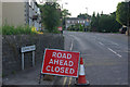
Tunnel Road, Beaminster
Tunnel Road, the A3066 towards Crewkerne, was closed following a landslip at the tunnel that burrows through Horn Hill. Sadly the incident had caused the loss of two lives.
Image: © Stephen McKay
Taken: 10 Aug 2012
0.11 miles
10
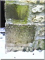
Benchmark on Flat #1 #63 Clay Lane
Ordnance Survey cut mark benchmark described on the Bench Mark Database at http://www.bench-marks.org.uk/bm36352
Image: © Roger Templeman
Taken: 22 Dec 2010
0.11 miles