IMAGES TAKEN NEAR TO
Shadrack Street, BEAMINSTER, DT8 3BE
Introduction
This page details the photographs taken nearby to Shadrack Street, DT8 3BE by members of the Geograph project.
The Geograph project started in 2005 with the aim of publishing, organising and preserving representative images for every square kilometre of Great Britain, Ireland and the Isle of Man.

There are currently over 7.5m images from over14,400 individuals and you can help contribute to the project by visiting https://www.geograph.org.uk
Image Map (Loading...)


Getting Data...Please wait
Leaflet Map data © OpenStreetMap
Images are licensed for reuse under creativecommons.org/licenses/by-sa/2.0
Notes
- Clicking on the map will re-center to the selected point.
- The higher the marker number, the further away the image location is from the centre of the postcode.
Image Listing (321 Images Found)
Images are licensed for reuse under creativecommons.org/licenses/by-sa/2.0
Image
Details
Distance
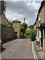
1
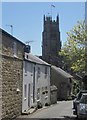
Shadrack Street, Beaminster
Leading towards the church, with some listed cottages further down the street.
Image: © Derek Harper
Taken: 22 Apr 2015
0.00 miles
2

Shadrack Street, Beaminster
Looking up the street from it junction with Church Street / Short's Lane (along which the Wessex Ridgeway passes). The early C19 house on the left is described at http://list.english-heritage.org.uk/resultsingle.aspx?uid=1210322&searchtype=mapsearch .
Image: © Derek Harper
Taken: 13 Apr 2014
0.01 miles
3
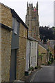
Shadrack Street, Beaminster
Shadrack Street is dominated by the impressive 16th century tower of St Mary's church.
Image: © Stephen McKay
Taken: 11 Aug 2012
0.01 miles
4
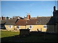
Terraced cottages Church Street
The cottages as viewed from the elevated position of the churchyard.
Image: © Sarah Smith
Taken: 21 Feb 2009
0.01 miles
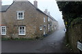
5

Church Street, Beaminster
From the junction with Shadrack Street. The nearest five cottages are all listed, grouped at http://list.english-heritage.org.uk/resultsingle.aspx?uid=1324198&searchtype=mapsearch and http://list.english-heritage.org.uk/resultsingle.aspx?uid=1118727&searchtype=mapsearch . The church is opposite and above them.
Image: © Derek Harper
Taken: 13 Apr 2014
0.02 miles
6
Wessex Ridgeway approaching Church Street, Beaminster
Entering the town along the long distance footpath on a mist shrouded January afternoon
Image: © Chris Heaton
Taken: 24 Jan 2017
0.02 miles
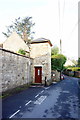
7
Beaminster, lift
In Church Street; what appears to be a turret against the wall of Image is in fact a lift, enabling visitors to reach the church without having to climb steep steps; door opened with a RADAR key, but out of order at the moment.
Image: © Mike Faherty
Taken: 24 Jun 2009
0.03 miles
8
Disabled access to St Mary's Church, Beaminster
Image: © Ian S
Taken: 29 May 2016
0.03 miles
9

Steps to the church, Beaminster
And to the Strode Room, the town's community hall, originally almshouses dating from 1630 http://list.english-heritage.org.uk/resultsingle.aspx?uid=1219625&searchtype=mapsearch . For those unable to manage steps, on the left is a modern lift tower designed to match the surrounding buildings. Seen from the Wessex Ridgeway as it passes along Church Street.
Image: © Derek Harper
Taken: 13 Apr 2014
0.03 miles
10
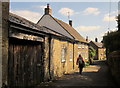
Short's Lane, Beaminster
A former smithy and a listed cottage http://list.english-heritage.org.uk/resultsingle.aspx?uid=1210328&searchtype=mapsearch on the lane approaching the church.
Image: © Derek Harper
Taken: 13 Apr 2014
0.03 miles