IMAGES TAKEN NEAR TO
Church Street, BEAMINSTER, DT8 3BA
Introduction
This page details the photographs taken nearby to Church Street, DT8 3BA by members of the Geograph project.
The Geograph project started in 2005 with the aim of publishing, organising and preserving representative images for every square kilometre of Great Britain, Ireland and the Isle of Man.

There are currently over 7.5m images from over14,400 individuals and you can help contribute to the project by visiting https://www.geograph.org.uk
Image Map (Loading...)


Getting Data...Please wait
Leaflet Map data © OpenStreetMap
Images are licensed for reuse under creativecommons.org/licenses/by-sa/2.0
Notes
- Clicking on the map will re-center to the selected point.
- The higher the marker number, the further away the image location is from the centre of the postcode.
Image Listing (318 Images Found)
Images are licensed for reuse under creativecommons.org/licenses/by-sa/2.0
Image
Details
Distance
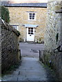
1

Church Street, Beaminster
In the foreground is a ramp into the churchyard. On the right are number 18 http://list.english-heritage.org.uk/resultsingle.aspx?uid=1118769&searchtype=mapsearch and numbers 20 and 22 http://list.english-heritage.org.uk/resultsingle.aspx?uid=1324197&searchtype=mapsearch .
Image: © Derek Harper
Taken: 13 Apr 2014
0.01 miles
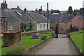
2
Steps from the Strode Room - Beaminster
This flight of steps lead down from the Strode Room, now a public hall having been a priest house then almshouses, to Church Street. One can also leave the churchyard by this way.
Image: © Sarah Smith
Taken: 21 Feb 2009
0.01 miles
3
Looking west-northwest along Church Street
Image: © Basher Eyre
Taken: 2 Sep 2013
0.01 miles
4

Churchyard, Beaminster
With Church Street on the left, including listed buildings http://list.english-heritage.org.uk/resultsingle.aspx?uid=1324197&searchtype=mapsearch http://list.english-heritage.org.uk/resultsingle.aspx?uid=1118769&searchtype=mapsearch . The wall along the edge is ten feet high, but not on this side http://list.english-heritage.org.uk/resultsingle.aspx?uid=1118729&searchtype=mapsearch . The table tomb is one seven listed as a group http://list.english-heritage.org.uk/resultsingle.aspx?uid=1118728&searchtype=mapsearch .
Image: © Derek Harper
Taken: 13 Apr 2014
0.01 miles
5
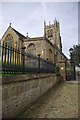
Beaminster Church
Seen here from Church Street, grade I listed St Mary's church dates from the 15th century although the tower is 16th century.
Image: © Stephen McKay
Taken: 11 Aug 2012
0.01 miles
6
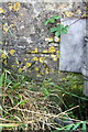
Benchmark on St Mary's Church
Ordnance Survey cut mark benchmark described on the Bench Mark Database at http://www.bench-marks.org.uk/bm45459
Image: © Roger Templeman
Taken: 21 Sep 2012
0.01 miles
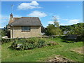

9
Beaminster Churchyard
The path leads out on to Church Street a short walk from the town's square.
Image: © Stephen McKay
Taken: 11 Aug 2012
0.02 miles
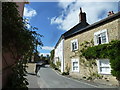
10
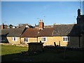
Terraced cottages Church Street
The cottages as viewed from the elevated position of the churchyard.
Image: © Sarah Smith
Taken: 21 Feb 2009
0.02 miles