IMAGES TAKEN NEAR TO
The Gables, LYME REGIS, DT7 3XZ
Introduction
This page details the photographs taken nearby to The Gables, DT7 3XZ by members of the Geograph project.
The Geograph project started in 2005 with the aim of publishing, organising and preserving representative images for every square kilometre of Great Britain, Ireland and the Isle of Man.

There are currently over 7.5m images from over14,400 individuals and you can help contribute to the project by visiting https://www.geograph.org.uk
Image Map
Images are licensed for reuse under creativecommons.org/licenses/by-sa/2.0
Notes
- Clicking on the map will re-center to the selected point.
- The higher the marker number, the further away the image location is from the centre of the postcode.
Image Listing (15 Images Found)
Images are licensed for reuse under creativecommons.org/licenses/by-sa/2.0
Image
Details
Distance

2

Ordnance Survey Flush Bracket 2148
This can be found on the wall of the former school - now Peak Hall - at Rousdon.
For more detail see : http://www.bench-marks.org.uk/bm10130
Image: © Peter Wood
Taken: 2 Apr 2014
0.01 miles
3
Old Guide Stone by the A3052, Rousdon
War Memorial by the A3052, in parish of Combpyne Rousdon (East Devon District), Rousdon, opposite Northern gateway to Rousdon Estate, a War Memorial on grass triangle, opposite County House, at junction with minor road to Combpyne. https://artuk.org/discover/artworks/milestone-and-war-memorial-308063
Inscription reads:-
ROUSDON :: SEATON 4½ / SIDMOUTH 12 :: COMBPYNE 1 / AXMINSTER 6½ :: LYME REGIS 3 / BRIDPORT 11½
Grade II listed.
List Entry Number: 1170578 https://historicengland.org.uk/listing/the-list/list-entry/1170578
Surveyed
Milestone Society National ID: DV_EXLR25z
Image: © Alan Rosevear
Taken: 27 Mar 2012
0.03 miles
4
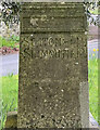
Old Milestone by the A3052, Rousdon
War Memorial by the A3052, in parish of Combpyne Rousdon (East Devon District), Rousdon, opposite Northern gateway to Rousdon Estate, a War Memorial on grass triangle, opposite County House, at junction with minor road to Combpyne. https://artuk.org/discover/artworks/milestone-and-war-memorial-308063
Inscription reads:-
ROUSDON :: SEATON 4½ / SIDMOUTH 12 :: COMBPYNE 1 / AXMINSTER 6½ :: LYME REGIS 3 / BRIDPORT 11½
Grade II listed.
List Entry Number: 1170578 https://historicengland.org.uk/listing/the-list/list-entry/1170578
Surveyed
Milestone Society National ID: DV_EXLR25z
Image: © Steve Szymanski
Taken: 10 Apr 2024
0.03 miles
5
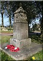
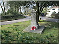
War memorial at Rousdon
The memorial is marked as a direction indicator with the village name facing the A3052 and names of local towns on the sides.
Image: © David Smith
Taken: 10 Oct 2012
0.04 miles
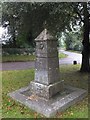
6
Rousdon War Memorial
War memorial on the green at Rousdon.
Image: © T Eyre
Taken: 5 Apr 2013
0.04 miles
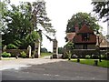
8
The gateway to the Rousdon Estate
The estate includes a number of private houses, on the site of the former Allhallows School
Image: © David Smith
Taken: 10 Oct 2012
0.05 miles
9

House in Rousdon
This chalet bungalow is on the north side of the A35 in what was the old village. Most recent residential development has taken place on the Rousdon estate round the old large house and former school which is south of the main road.
Image: © Nigel Mykura
Taken: 29 Sep 2017
0.06 miles
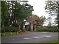
10

Combpyne Rousdon: house at Rousdon
Grindon, looking north east by the entrance, with a rain cloud overhead
Image: © Martin Bodman
Taken: 16 Dec 2006
0.10 miles