IMAGES TAKEN NEAR TO
Masters Close, LYME REGIS, DT7 3XN
Introduction
This page details the photographs taken nearby to Masters Close, DT7 3XN by members of the Geograph project.
The Geograph project started in 2005 with the aim of publishing, organising and preserving representative images for every square kilometre of Great Britain, Ireland and the Isle of Man.

There are currently over 7.5m images from over14,400 individuals and you can help contribute to the project by visiting https://www.geograph.org.uk
Image Map
Images are licensed for reuse under creativecommons.org/licenses/by-sa/2.0
Notes
- Clicking on the map will re-center to the selected point.
- The higher the marker number, the further away the image location is from the centre of the postcode.
Image Listing (71 Images Found)
Images are licensed for reuse under creativecommons.org/licenses/by-sa/2.0
Image
Details
Distance

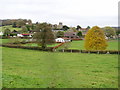
3
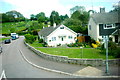
Houses in Uplyme
These houses are on the corner of Cooks Mead and the Lyme Rd in Uplyme. In the background can be seen the tower of Uplyme church in Pound Lane.
Image: © Nigel Mykura
Taken: 23 May 2015
0.08 miles
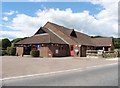
5
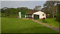
Uplyme & Lyme Regis Cricket Club - Pavilion
Uplyme & Lyme Regis run two teams in the Devon Cricket League
Image: © BatAndBall
Taken: 6 May 2017
0.09 miles
6
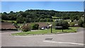
Ethelston's Close, Uplyme
From the junction with Pound Lane. Beyond is the Lim valley, with small woods on the other slope. The apostrophe in "Ethelston's" appears on maps, but, as you can see, not on the street name sign. However, opposite is Mrs Ethelston's Primary School, so it seems justified to include it.
Image: © Derek Harper
Taken: 31 Jul 2015
0.10 miles
7
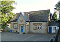
Mrs Ethelston's C of E Primary School, Uplyme
An outstanding village school, according to a very recent inspection.
Image: © Philip Pankhurst
Taken: 9 Jul 2013
0.10 miles
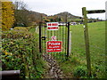
8
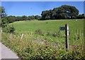
Bridleway, Uplyme
The sign points along Uplyme Bridleway 72 as it leaves Lime Kiln Lane, following a farm road to Carswell Farm. The wood left of centre is Court Hall Coppice.
Image: © Derek Harper
Taken: 31 Jul 2015
0.10 miles
9
East Devon Way
The footpath approaches Uplyme and Lyme Regis Cricket Clubhouse and grounds.
Image: © Peter Holmes
Taken: 14 Nov 2008
0.10 miles