IMAGES TAKEN NEAR TO
Uplyme, LYME REGIS, DT7 3SP
Introduction
This page details the photographs taken nearby to DT7 3SP by members of the Geograph project.
The Geograph project started in 2005 with the aim of publishing, organising and preserving representative images for every square kilometre of Great Britain, Ireland and the Isle of Man.

There are currently over 7.5m images from over14,400 individuals and you can help contribute to the project by visiting https://www.geograph.org.uk
Image Map
Images are licensed for reuse under creativecommons.org/licenses/by-sa/2.0
Notes
- Clicking on the map will re-center to the selected point.
- The higher the marker number, the further away the image location is from the centre of the postcode.
Image Listing (30 Images Found)
Images are licensed for reuse under creativecommons.org/licenses/by-sa/2.0
Image
Details
Distance
1
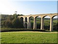
The reinforced arch of Cannington Viaduct
During the construction of this viaduct, one of the first two in the country to be made entirely from unreinforced concrete, the builders encountered subsidence problems and had to partly fill in this particular arch.
For a 360° interactive panorama of the whole viaduct, please visit this http://www.360panoramas.co.uk/index.php?page=Cannington+Viaduct§ion=4&id=94
Image: © M Etherington
Taken: 23 Oct 2007
0.07 miles
2
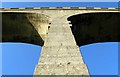
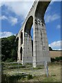
Cannington Viaduct detail
A close-up of one of the solid concrete arches of the Cannington Viaduct, part of the dismantled local branch line to Lyme Regis.
For a complete 360° interactive panorama of the viaduct, lease visit this http://www.360panoramas.co.uk/index.php?page=Cannington+Viaduct§ion=4&id=94
Image: © M Etherington
Taken: 24 Oct 2007
0.10 miles
3
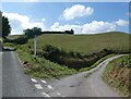
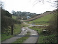
Track and road, Alder Grove
A curious spot. The unfenced lane through Shapwick Grange Farm performs an extravagant hairpin off to the left here, although it is scarcely doing so in order to gain height. At the point of the hairpin is the entrance road into Uplyme Quarry, which works chalk and sandstone http://www.devon.gov.uk/amlp-ip20_uplyme_quarry.pdf . Clearly impatient with the circuitous route around the bend, vehicles have carved short cuts across the neck of it, of which this is one. The chalk is much in evidence. Alder Grove is the wood on the right. You can see Shapwick Cottages up the valley ahead.
Image: © Derek Harper
Taken: 31 Jul 2015
0.11 miles
4
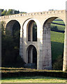
Cannington Viaduct
This 600ft long viaduct was opened in August 1903 to carry steam trains on the branch line from Axminster to Lyme Regis. It was one of the first two railway viaducts in the UK to be constructed entirely from mass concrete that had not been reinforced, the other being the Borrodale Viaduct. Unfortunately the builders encountered subsidence and had to fill-in and reinforce the arch on the left.
Sadly the line was closed in 1965 and this is all that remains except for the original Lyme Regis Station, which was rescued and now used as a buffet at Alresford station in Hampshire.
For an interactive 360° panorama visit this http://www.360panoramas.co.uk/index.php?page=Cannington+Viaduct§ion=4&id=94
Image: © M Etherington
Taken: 23 Oct 2007
0.12 miles
7

Cannington Viaduct
Looking up at Cannington Viaduct.
Image: © T Eyre
Taken: 28 Aug 2015
0.16 miles
8
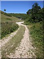
Track to the quarry by Shapwick Grange farm
Image: © Sarah Charlesworth
Taken: 7 Feb 2010
0.17 miles
9
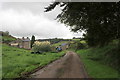
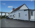
Shapwick Grange
Shapwick Grange is a large old farm on a quiet backwater with unfenced roads and cattle grids.
Image: © Nigel Mykura
Taken: 29 Sep 2017
0.17 miles