IMAGES TAKEN NEAR TO
LYME REGIS, DT7 3RG
Introduction
This page details the photographs taken nearby to DT7 3RG by members of the Geograph project.
The Geograph project started in 2005 with the aim of publishing, organising and preserving representative images for every square kilometre of Great Britain, Ireland and the Isle of Man.

There are currently over 7.5m images from over14,400 individuals and you can help contribute to the project by visiting https://www.geograph.org.uk
Image Map
Images are licensed for reuse under creativecommons.org/licenses/by-sa/2.0
Notes
- Clicking on the map will re-center to the selected point.
- The higher the marker number, the further away the image location is from the centre of the postcode.
Image Listing (6 Images Found)
Images are licensed for reuse under creativecommons.org/licenses/by-sa/2.0
Image
Details
Distance
1
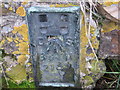
Ordnance Survey Flush Bracket 2147
This can be found on a roadside wall in front of Pinhay Cottages.
For more detail see : http://www.bench-marks.org.uk/bm10129
Image: © Peter Wood
Taken: 2 Apr 2014
0.01 miles
2
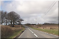
A3052 west of Charlton Cross
Close to Whitlands
Image: © John Firth
Taken: 12 Apr 2013
0.08 miles
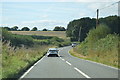
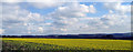
5

Fields at Charton Cross
The trees on the opposite side of the field mark the track leading to the property known as Whitlands
Image: © Nigel Mykura
Taken: 29 Sep 2017
0.20 miles
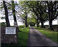
6
View from near Headland Farm looking east
Image: © M Etherington
Taken: 3 May 2010
0.20 miles