IMAGES TAKEN NEAR TO
Rousdon, LYME REGIS, DT7 3RF
Introduction
This page details the photographs taken nearby to DT7 3RF by members of the Geograph project.
The Geograph project started in 2005 with the aim of publishing, organising and preserving representative images for every square kilometre of Great Britain, Ireland and the Isle of Man.

There are currently over 7.5m images from over14,400 individuals and you can help contribute to the project by visiting https://www.geograph.org.uk
Image Map
Images are licensed for reuse under creativecommons.org/licenses/by-sa/2.0
Notes
- Clicking on the map will re-center to the selected point.
- The higher the marker number, the further away the image location is from the centre of the postcode.
Image Listing (19 Images Found)
Images are licensed for reuse under creativecommons.org/licenses/by-sa/2.0
Image
Details
Distance
1
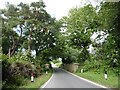
Former railway bridge on Trinity Hill Road
Image: © Roger Cornfoot
Taken: 22 Jun 2020
0.02 miles
2
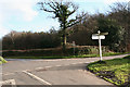
Combpyne Rousdon: crossroads at Charlton Plantation
Turn right for Rousdon and Seaton. Axminster is five miles away to the north. Looking east-south-east. Just north of the crossroads the Axminster-Lyme Regis branch railway ran in a deep cutting, now partially filled in
Image: © Martin Bodman
Taken: 16 Dec 2006
0.02 miles
3
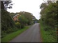
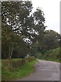
Lidyates Lane leading to crossroads at Charton Plantation
Image: © David Smith
Taken: 10 Oct 2012
0.02 miles
4
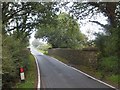
Bridge over former railway
Trinity Hill Road crossing the former Axminster to Lyme Regis branch line
Image: © David Smith
Taken: 10 Oct 2012
0.03 miles
6
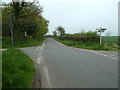
Road junction north of the A3052
This is a road junction for Shapwick, Combpyne, Seaton and Axminster roads. The disused railway passes behind the photographer.
Image: © Stuart Buchan
Taken: 6 May 2006
0.05 miles
7
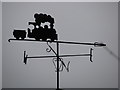
Weathervane on a house on the site of the old Combpyne halt on the Lyme Regis branch line
Image: © Sarah Charlesworth
Taken: 7 Feb 2010
0.10 miles
9
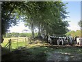
Cattle near Combpyne Station
The site of the station, that is. Behind the cattle are the vestiges of an old barn.
Image: © Derek Harper
Taken: 31 Jul 2015
0.11 miles
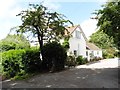
10
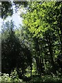
Charton Copse
On the right side of the lane shown in Image
Image: © Derek Harper
Taken: 31 Jul 2015
0.13 miles