IMAGES TAKEN NEAR TO
Haye Lane, LYME REGIS, DT7 3NH
Introduction
This page details the photographs taken nearby to Haye Lane, DT7 3NH by members of the Geograph project.
The Geograph project started in 2005 with the aim of publishing, organising and preserving representative images for every square kilometre of Great Britain, Ireland and the Isle of Man.

There are currently over 7.5m images from over14,400 individuals and you can help contribute to the project by visiting https://www.geograph.org.uk
Image Map
Images are licensed for reuse under creativecommons.org/licenses/by-sa/2.0
Notes
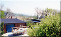
- Clicking on the map will re-center to the selected point.
- The higher the marker number, the further away the image location is from the centre of the postcode.
Image Listing (117 Images Found)
Images are licensed for reuse under creativecommons.org/licenses/by-sa/2.0
Image
Details
Distance
1
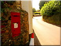
Lyme Regis: postbox № DT7 135, Haye Lane
A Victorian box on a tight bend in this narrow lane. It is emptied finally at 5:45pm on weekdays and at noon on Saturdays.
Image: © Chris Downer
Taken: 12 Sep 2009
0.03 miles
2
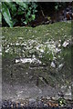
Benchmark on Haye Lane culvert
Ordnance Survey cut mark benchmark described on the Bench Mark Database at http://www.bench-marks.org.uk/bm32301
Image: © Roger Templeman
Taken: 18 Sep 2012
0.04 miles
3
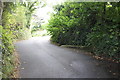
Haye Lane from Roman Road junction
There is an OS benchmark Image on the road face of the concrete culvert in the middle of the image (right hand side of the road)
Image: © Roger Templeman
Taken: 18 Sep 2012
0.04 miles
4
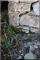
Benchmark on wall of Roman Road
Ordnance Survey cut mark benchmark described on the Bench Mark Database at http://www.bench-marks.org.uk/bm45415
Image: © Roger Templeman
Taken: 18 Sep 2012
0.07 miles
5
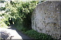
Roman Road - no through road for vehicles
There is an OS benchmark Image on the far end of the wall which was originally the wall of a building
Image: © Roger Templeman
Taken: 18 Sep 2012
0.07 miles
6
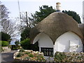
Umbrella Cottage, Lyme Regis
This very picturesque thatched cottage dates from the early 19th century and was originally a tollhouse.
Image: © Richard Slessor
Taken: 5 Apr 2005
0.07 miles
7
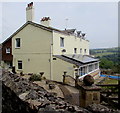
St Andrews House B&B, Lyme Regis
Bed & breakfast accommodation in St Andrews House located below the B3165 Uplyme Road.
A swimming pool is in the background on the right.
Image: © Jaggery
Taken: 13 Jun 2018
0.08 miles
8
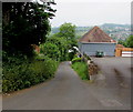
Steep narrow descent in Lyme Regis
Roman Road descends from the B3165.
Image: © Jaggery
Taken: 13 Jun 2018
0.08 miles
9
Site of Lyme Regis station, 2000
View SE from B3165 Uplyme Road, by District Hospital: terminus of ex-LSWR branch from Axminster. The station and branch had been closed 29//11/65 - not a trace of railway to be seen.
Image: © Ben Brooksbank
Taken: 2 May 2000
0.09 miles
10
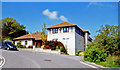
Lyme Regis District Hospital, Uplyme Road, 2000
View NW, opposite the - estimated - site of the former railway terminus, Lyme Regis town being to the right; see Image
Image: © Ben Brooksbank
Taken: 2 May 2000
0.09 miles