IMAGES TAKEN NEAR TO
Launchycroft, LYME REGIS, DT7 3NF
Introduction
This page details the photographs taken nearby to Launchycroft, DT7 3NF by members of the Geograph project.
The Geograph project started in 2005 with the aim of publishing, organising and preserving representative images for every square kilometre of Great Britain, Ireland and the Isle of Man.

There are currently over 7.5m images from over14,400 individuals and you can help contribute to the project by visiting https://www.geograph.org.uk
Image Map
Images are licensed for reuse under creativecommons.org/licenses/by-sa/2.0
Notes
- Clicking on the map will re-center to the selected point.
- The higher the marker number, the further away the image location is from the centre of the postcode.
Image Listing (40 Images Found)
Images are licensed for reuse under creativecommons.org/licenses/by-sa/2.0
Image
Details
Distance
1
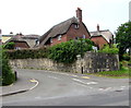
Thatched roof cottages, Woodroffe Meadow, Lyme Regis
Viewed across Uplyme Road.
Image: © Jaggery
Taken: 13 Jun 2018
0.04 miles
2
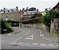
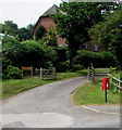
Woodroffe Meadow, Lyme Regis
Northern end of the cul-de-sac Woodroffe Meadow viewed across Uplyme Road.
Image: © Jaggery
Taken: 13 Jun 2018
0.05 miles
3
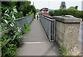
Parallel footbridge and road bridge, Uplyme Road, Lyme Regis
The footbridge is on the west side of the B3165 Uplyme Road bridge.
The double-decker bus https://www.geograph.org.uk/photo/5808913 is on route X53 to Axminster.
Image: © Jaggery
Taken: 13 Jun 2018
0.05 miles
5
Lyme Regis: postbox № DT7 49, Uplyme Road
Looking northwest along Uplyme Road over the old railway bridge. The county boundary sign is in the distance, looking along the path.
Image: © Chris Downer
Taken: 27 Sep 2008
0.06 miles
6
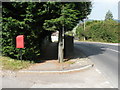
Queen Elizabeth II postbox near Launchycroft, Lyme Regis
Alongside Uplyme Road. The entrance to Launchycroft is in the background.
Image: © Jaggery
Taken: 13 Jun 2018
0.06 miles
7
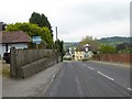
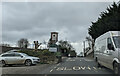
B3165 entering Uplyme and crossing the Dorset-Devon border
The sign by the county border advertises the Black Dog tea rooms. Image shows the earlier sign when it advertises the Black Dog as a guest house
Image: © David Smith
Taken: 1 Jun 2016
0.06 miles
8
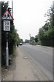
School 20 when lights show warning sign at the edge of Lyme Regis
On the approach to Woodroffe School, the 30mph speed limit on the B3165 drops to 20 when the lights show.
Image: © Jaggery
Taken: 13 Jun 2018
0.06 miles
9
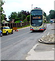
X53 bus for Axminster in Lyme Regis
The doubler-decker bus is travelling north on the B3165 Uplyme Road.
Image: © Jaggery
Taken: 13 Jun 2018
0.06 miles
10
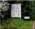
Welcome to Lyme Regis - Ancient Royal Borough
The B3165 from Uplyme, Devon reaches the northern boundary of Lyme Regis, Dorset.
The sign shows that Lyme Regis is twinned with St George's Bermuda and Barfleur France. Viewed in June 2018. The soldier silhouette and Royal British Legion 1914-1918 Lest We Forget notice were not here in an April 2017 Google Earth Street View.
Image: © Jaggery
Taken: 13 Jun 2018
0.06 miles