IMAGES TAKEN NEAR TO
Clappentail Lane, LYME REGIS, DT7 3LY
Introduction
This page details the photographs taken nearby to Clappentail Lane, DT7 3LY by members of the Geograph project.
The Geograph project started in 2005 with the aim of publishing, organising and preserving representative images for every square kilometre of Great Britain, Ireland and the Isle of Man.

There are currently over 7.5m images from over14,400 individuals and you can help contribute to the project by visiting https://www.geograph.org.uk
Image Map
Images are licensed for reuse under creativecommons.org/licenses/by-sa/2.0
Notes
- Clicking on the map will re-center to the selected point.
- The higher the marker number, the further away the image location is from the centre of the postcode.
Image Listing (102 Images Found)
Images are licensed for reuse under creativecommons.org/licenses/by-sa/2.0
Image
Details
Distance
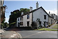
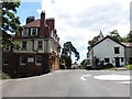
2
House at the northern end of Clappentail Lane, Lyme Regis
On the corner of the B3165.
Image: © Jaggery
Taken: 13 Jun 2018
0.01 miles
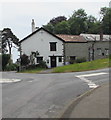
3
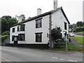
Grade II Listed Clappentail House, Lyme Regis
The B3165 side of the house on the corner of Clappentail Lane.
Historic England records that the building dates from the 18th century, possibly earlier.
Image: © Jaggery
Taken: 13 Jun 2018
0.01 miles
4
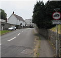
Clappentail Lane, Lyme Regis
From the south side of the B3165, Clappentail Lane ascends towards Clappentail Park.
Image: © Jaggery
Taken: 13 Jun 2018
0.01 miles
6
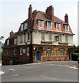
Victoria House, Lyme Regis
The former railway hotel on the corner of Silver Street and Roman Road
provides self-catering holiday accommodation with 11 bedrooms and 10 bathrooms.
Image: © Jaggery
Taken: 13 Jun 2018
0.02 miles
7
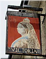
Victoria name sign, Victoria House, Lyme Regis
Faded in June 2018, the depiction of an elderly
Queen Victoria hangs from a wall bracket here. https://www.geograph.org.uk/photo/6143668
Image: © Jaggery
Taken: 13 Jun 2018
0.02 miles
8
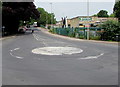
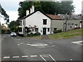
B3165 mini-roundabout, Lyme Regis
The B3165 is Silver Street to the southeast of this roundabout, Uplyme Road to the northwest (ahead).
Image: © Jaggery
Taken: 13 Jun 2018
0.02 miles
10
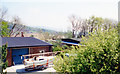
Site of Lyme Regis station, 2000
View SE from B3165 Uplyme Road, by District Hospital: terminus of ex-LSWR branch from Axminster. The station and branch had been closed 29//11/65 - not a trace of railway to be seen.
Image: © Ben Brooksbank
Taken: 2 May 2000
0.02 miles