IMAGES TAKEN NEAR TO
West Hill Road, LYME REGIS, DT7 3LW
Introduction
This page details the photographs taken nearby to West Hill Road, DT7 3LW by members of the Geograph project.
The Geograph project started in 2005 with the aim of publishing, organising and preserving representative images for every square kilometre of Great Britain, Ireland and the Isle of Man.

There are currently over 7.5m images from over14,400 individuals and you can help contribute to the project by visiting https://www.geograph.org.uk
Image Map
Images are licensed for reuse under creativecommons.org/licenses/by-sa/2.0
Notes
- Clicking on the map will re-center to the selected point.
- The higher the marker number, the further away the image location is from the centre of the postcode.
Image Listing (181 Images Found)
Images are licensed for reuse under creativecommons.org/licenses/by-sa/2.0
Image
Details
Distance
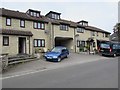
1
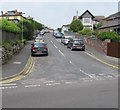
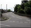
Up Hill Rise Road, Lyme Regis
Hill Rise Road ascends from Pound Road towards West Hill Road.
Image: © Jaggery
Taken: 13 Jun 2018
0.07 miles
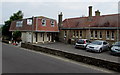
2
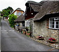
Thatched roof, Pound Road, Lyme Regis
Set back from the west side of Pound Road opposite Kersbrook guesthouse.
Another thatched roof building is in the background.
Image: © Jaggery
Taken: 13 Jun 2018
0.07 miles
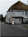
3
Kersbrook Cottage, Pound Road, Lyme Regis
Grade II listed thatched cottage dating from the 18th century. In June 2018
the cottage is part of the AA 4-star rated Kersbrook Guest Accommodation.
Image: © Jaggery
Taken: 13 Jun 2018
0.08 miles
4
Kersbrook guesthouse, Pound Road, Lyme Regis
Kersbrook provides bed & breakfast accommodation in a Grade II listed thatched roof cottage.
Image: © Jaggery
Taken: 13 Jun 2018
0.08 miles
5
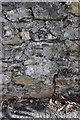
Benchmark on the wall of Pound Road
Ordnance Survey cut mark benchmark described on the Bench Mark Database at http://www.bench-marks.org.uk/bm45419
Image: © Roger Templeman
Taken: 18 Sep 2012
0.08 miles
6
Pound Road at entrance to 'Little West Hill'
There is an OS benchmark Image on a stone in the wall about 2m from the entrance
Image: © Roger Templeman
Taken: 18 Sep 2012
0.08 miles
7
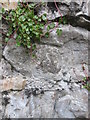
Ordnance Survey Cut Mark
This OS cut mark can be found on the wall of Pound Road. It marks a point 67.474m above mean sea level.
Image: © Adrian Dust
Taken: 27 Mar 2015
0.08 miles
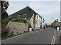
8
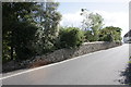
West Hill Road, Lyme Regis
From the B3165, West Hill Road ascends towards Hill Rise Road.
Image: © Jaggery
Taken: 13 Jun 2018
0.08 miles
9
Kersbrook Gardens, Pound Road, Lyme Regis
Joe the Plumber's van is parked near the Kersbrook Gardens name sign on the west side of Pound Road.
Image: © Jaggery
Taken: 13 Jun 2018
0.09 miles
10
Lyme Regis Nursing Home
At 14 Pound Road, Lyme Regis.
Image: © Jaggery
Taken: 13 Jun 2018
0.09 miles