IMAGES TAKEN NEAR TO
Somer Fields, LYME REGIS, DT7 3EZ
Introduction
This page details the photographs taken nearby to Somer Fields, DT7 3EZ by members of the Geograph project.
The Geograph project started in 2005 with the aim of publishing, organising and preserving representative images for every square kilometre of Great Britain, Ireland and the Isle of Man.

There are currently over 7.5m images from over14,400 individuals and you can help contribute to the project by visiting https://www.geograph.org.uk
Image Map
Images are licensed for reuse under creativecommons.org/licenses/by-sa/2.0
Notes
- Clicking on the map will re-center to the selected point.
- The higher the marker number, the further away the image location is from the centre of the postcode.
Image Listing (47 Images Found)
Images are licensed for reuse under creativecommons.org/licenses/by-sa/2.0
Image
Details
Distance
2
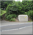
Woodroffe School electricity substation, Lyme Regis
Located here https://www.geograph.org.uk/photo/6185774 the grey cabinet is a Western Power Distribution electricity substation.
Its identifier is WOODROFFE SCHOOL 258790.
Image: © Jaggery
Taken: 13 Jun 2018
0.16 miles
3
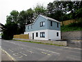
New house, Uplyme Road, Lyme Regis
In June 2018 FOR SALE notices are in windows of the recently-built house alongside the B3165 Uplyme Road.
An April 2017 Google Street View shows a fenced-off building site here.
Image: © Jaggery
Taken: 13 Jun 2018
0.16 miles
4
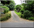
Penny Plot, Lyme Regis
Penny Plot is a dead-end road on the SW side of the B3165 Uplyme Road.
Image: © Jaggery
Taken: 13 Jun 2018
0.16 miles
5
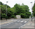
Zebra crossing, Uplyme Road, Lyme Regis
The B3165 Uplyme Road zebra crossing has combined Belisha beacons and street lamps.
Image: © Jaggery
Taken: 13 Jun 2018
0.16 miles
6
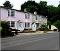
Braeside, Lyme Regis
Braeside on the left is alongside the B3165 Uplyme Road.
Image: © Jaggery
Taken: 13 Jun 2018
0.16 miles
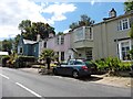
7
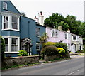
Pink cottage, Uplyme Road, Lyme Regis
Spring Cottage viewed across the B3165 Uplyme Road.
Image: © Jaggery
Taken: 13 Jun 2018
0.17 miles
8
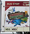
Jurassic Coaster bus stop sign, Uplyme Road, Lyme Regis
On top of this https://www.geograph.org.uk/photo/6185864 shelter.
Image: © Jaggery
Taken: 13 Jun 2018
0.17 miles
9
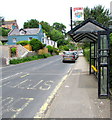
X51 and X53 bus stop and shelter, Uplyme Road, Lyme Regis
The bus stop sign on the shelter shows JURASSIC COASTER. https://www.geograph.org.uk/photo/6185867
Image: © Jaggery
Taken: 13 Jun 2018
0.17 miles
10

Uplyme Road Business Park information board in a hedge, Lyme Regis
Unit occupiers information facing Uplyme Road in June 2018.
Image: © Jaggery
Taken: 13 Jun 2018
0.17 miles