IMAGES TAKEN NEAR TO
Highcliff Road, LYME REGIS, DT7 3EW
Introduction
This page details the photographs taken nearby to Highcliff Road, DT7 3EW by members of the Geograph project.
The Geograph project started in 2005 with the aim of publishing, organising and preserving representative images for every square kilometre of Great Britain, Ireland and the Isle of Man.

There are currently over 7.5m images from over14,400 individuals and you can help contribute to the project by visiting https://www.geograph.org.uk
Image Map
Images are licensed for reuse under creativecommons.org/licenses/by-sa/2.0
Notes
- Clicking on the map will re-center to the selected point.
- The higher the marker number, the further away the image location is from the centre of the postcode.
Image Listing (97 Images Found)
Images are licensed for reuse under creativecommons.org/licenses/by-sa/2.0
Image
Details
Distance
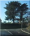
2

High Cliff Lodge, Lyme Regis
Set back from the north side of the A3052 Sidmouth Road.
Image: © Jaggery
Taken: 13 Jun 2018
0.06 miles
3
High Cliff Cottage, Lyme Regis
Set back from the north side of the A3052 Sidmouth Road.
The sign on the left warns that there is no footway for 160 yards.
Patchy sea fog obscures trees on the right at 3:37pm on June 13th 2018.
Image: © Jaggery
Taken: 13 Jun 2018
0.06 miles
4
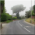
Patchy sea fog, Sidmouth Road, Lyme Regis
Viewed at 3:36pm on June 13th 2018.
Image: © Jaggery
Taken: 13 Jun 2018
0.06 miles
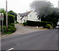
5
Ware Corner at junction of Ware Lane and Sidmouth Road
There is an OS benchmark Image on the near angle of the house on the shaded face
Image: © Roger Templeman
Taken: 18 Sep 2012
0.07 miles
6
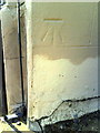
Benchmark on house at Ware Corner
Ordnance Survey cut mark benchmark described on the Bench Mark Database at http://www.bench-marks.org.uk/bm45418
Image: © Roger Templeman
Taken: 18 Sep 2012
0.07 miles
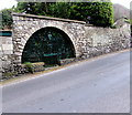
7
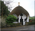
Old Toll House by Sidmouth Road, Lyme Regis
Toll House by the A3052, in the parish of Lyme Regis (West Dorset District), Umbrella Cottage, Sidmouth Road, DT7.
Grade II listed.
List Entry Number: 1230314 https://historicengland.org.uk/listing/the-list/list-entry/1230314
Surveyed
Milestone Society National ID: DO.LYM
Image: © Alan Rosevear
Taken: Unknown
0.07 miles
8
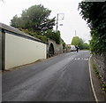
Up Sidmouth Road, Lyme Regis
The A3052 Sidmouth Road climbs westwards away from Lyme Regis.
An ornate green gate https://www.geograph.org.uk/photo/5816343 is in the arch on the left.
Image: © Jaggery
Taken: 13 Jun 2018
0.07 miles
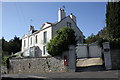
9
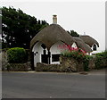
Umbrella Cottage, Sidmouth Road, Lyme Regis
Thatched roof cottage probably dating from the early 19th century with later alterations. Grade II listed in 1952.
Image: © Jaggery
Taken: 13 Jun 2018
0.07 miles
10
Ornate green gate at an entrance to Little Cliff, Sidmouth Road, Lyme Regis
On the south side of the A3052 Sidmouth Road.
Image: © Jaggery
Taken: 13 Jun 2018
0.07 miles