IMAGES TAKEN NEAR TO
Sidmouth Road, LYME REGIS, DT7 3EP
Introduction
This page details the photographs taken nearby to Sidmouth Road, DT7 3EP by members of the Geograph project.
The Geograph project started in 2005 with the aim of publishing, organising and preserving representative images for every square kilometre of Great Britain, Ireland and the Isle of Man.

There are currently over 7.5m images from over14,400 individuals and you can help contribute to the project by visiting https://www.geograph.org.uk
Image Map
Images are licensed for reuse under creativecommons.org/licenses/by-sa/2.0
Notes
- Clicking on the map will re-center to the selected point.
- The higher the marker number, the further away the image location is from the centre of the postcode.
Image Listing (79 Images Found)
Images are licensed for reuse under creativecommons.org/licenses/by-sa/2.0
Image
Details
Distance
1
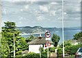
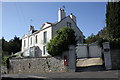
Above Lyme Regis
Looking east from Sidmouth Road.
Image: © Pierre Terre
Taken: 20 Jun 2009
0.01 miles
3
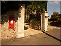
Lyme Regis: postbox № DT7 146, Somers Road
This Elizabeth II-reign postbox is emptied finally at 4pm on weekdays and at noon on Saturdays. Ahead of us, we see the A3052 Sidmouth Road heading towards the town suggested in its name.
Image: © Chris Downer
Taken: 12 Sep 2009
0.08 miles
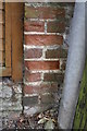
4
Benchmark on house at Ware Corner
Ordnance Survey cut mark benchmark described on the Bench Mark Database at http://www.bench-marks.org.uk/bm45418
Image: © Roger Templeman
Taken: 18 Sep 2012
0.09 miles
5
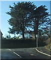
Ware Corner at junction of Ware Lane and Sidmouth Road
There is an OS benchmark Image on the near angle of the house on the shaded face
Image: © Roger Templeman
Taken: 18 Sep 2012
0.09 miles
6
Lyme Regis: postbox № DT7 29, Sidmouth Road
This Elizabeth II-reign postbox stands on the corner of Ware Lane and is emptied finally at 5:45pm on weekdays (curiously the latest in the town) and at 11:45am on Saturdays.
Image: © Chris Downer
Taken: 12 Sep 2009
0.11 miles
7
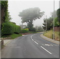
Patchy sea fog, Sidmouth Road, Lyme Regis
Viewed at 3:36pm on June 13th 2018.
Image: © Jaggery
Taken: 13 Jun 2018
0.11 miles
8
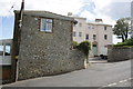
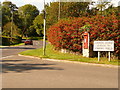
Old Stable Cottage, Clappentail Lane
There is an OS benchmark Image on the brickwork to the left of the electricity pole
Image: © Roger Templeman
Taken: 18 Sep 2012
0.13 miles
9
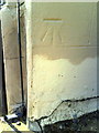
Weathered benchmark on Old Stable Cottage, Clappentail Lane
Ordnance Survey cut mark benchmark described on the Bench Mark Database at http://www.bench-marks.org.uk/bm45412
Image: © Roger Templeman
Taken: 18 Sep 2012
0.13 miles
10
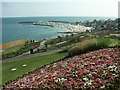
Langmoor Gardens, Lyme Regis
Looking down towards the beach, harbour and Cobb.
Image: © Katy Walters
Taken: 22 Jul 2006
0.14 miles