IMAGES TAKEN NEAR TO
Ware Lane, LYME REGIS, DT7 3EL
Introduction
This page details the photographs taken nearby to Ware Lane, DT7 3EL by members of the Geograph project.
The Geograph project started in 2005 with the aim of publishing, organising and preserving representative images for every square kilometre of Great Britain, Ireland and the Isle of Man.

There are currently over 7.5m images from over14,400 individuals and you can help contribute to the project by visiting https://www.geograph.org.uk
Image Map
Images are licensed for reuse under creativecommons.org/licenses/by-sa/2.0
Notes
- Clicking on the map will re-center to the selected point.
- The higher the marker number, the further away the image location is from the centre of the postcode.
Image Listing (45 Images Found)
Images are licensed for reuse under creativecommons.org/licenses/by-sa/2.0
Image
Details
Distance
1
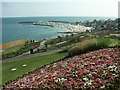
Langmoor Gardens, Lyme Regis
Looking down towards the beach, harbour and Cobb.
Image: © Katy Walters
Taken: 22 Jul 2006
0.01 miles
2
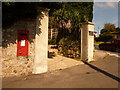
Lyme Regis: postbox № DT7 29, Sidmouth Road
This Elizabeth II-reign postbox stands on the corner of Ware Lane and is emptied finally at 5:45pm on weekdays (curiously the latest in the town) and at 11:45am on Saturdays.
Image: © Chris Downer
Taken: 12 Sep 2009
0.04 miles
3
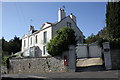
Ware Corner at junction of Ware Lane and Sidmouth Road
There is an OS benchmark Image on the near angle of the house on the shaded face
Image: © Roger Templeman
Taken: 18 Sep 2012
0.05 miles
4
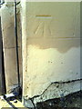
Benchmark on house at Ware Corner
Ordnance Survey cut mark benchmark described on the Bench Mark Database at http://www.bench-marks.org.uk/bm45418
Image: © Roger Templeman
Taken: 18 Sep 2012
0.05 miles
5
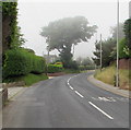
Patchy sea fog, Sidmouth Road, Lyme Regis
Viewed at 3:36pm on June 13th 2018.
Image: © Jaggery
Taken: 13 Jun 2018
0.07 miles
7
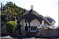
Umbrella Cottage, 1 Sidmouth Road, Lyme Regis
Grade II Listed cottage orné probably early 19th century and former gardener's cottage and/or Tollhouse. The principal structure is thought to have been built for the Lyme Regis Turnpike Trust (Charmouth to Whimple Division) in the 19th century in the form of a lodge. Pottery model indicates it was a tollhouse but it is possible that it was a lodge to Cobb House (or served both functions). Sidmouth Road Toll Gate is listed as being at this location. In January 2012 the Planning Committee recommended approval to a gravity foul sewer construction to connect Umbrella Cottage to public foul sewer within National Trust land.
Image: © Jo and Steve Turner
Taken: 15 Sep 2007
0.12 miles
8
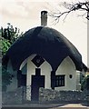
Lyme Regis: Umbrella Cottage
Built around 1810.
Image: © Chris Downer
Taken: Unknown
0.12 miles
9

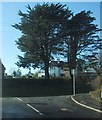
High Cliff Lodge, Lyme Regis
Set back from the north side of the A3052 Sidmouth Road.
Image: © Jaggery
Taken: 13 Jun 2018
0.12 miles
10
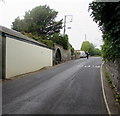
Up Sidmouth Road, Lyme Regis
The A3052 Sidmouth Road climbs westwards away from Lyme Regis.
An ornate green gate https://www.geograph.org.uk/photo/5816343 is in the arch on the left.
Image: © Jaggery
Taken: 13 Jun 2018
0.12 miles