IMAGES TAKEN NEAR TO
Talbot Road, LYME REGIS, DT7 3BA
Introduction
This page details the photographs taken nearby to Talbot Road, DT7 3BA by members of the Geograph project.
The Geograph project started in 2005 with the aim of publishing, organising and preserving representative images for every square kilometre of Great Britain, Ireland and the Isle of Man.

There are currently over 7.5m images from over14,400 individuals and you can help contribute to the project by visiting https://www.geograph.org.uk
Image Map
Images are licensed for reuse under creativecommons.org/licenses/by-sa/2.0
Notes
- Clicking on the map will re-center to the selected point.
- The higher the marker number, the further away the image location is from the centre of the postcode.
Image Listing (15 Images Found)
Images are licensed for reuse under creativecommons.org/licenses/by-sa/2.0
Image
Details
Distance
1
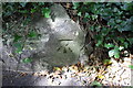
Benchmark on low wall of Colway Lane
Ordnance Survey cut mark described on the Bench Mark Database at http://www.bench-marks.org.uk/bm45410
Image: © Roger Templeman
Taken: 18 Sep 2012
0.10 miles
2
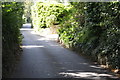
Colway Lane
There is an OS benchmark Image on the low concrete wall near the right hand side of the image where the overhanging ivy has been cleared
Image: © Roger Templeman
Taken: 18 Sep 2012
0.10 miles
3
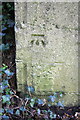
Benchmark on the wall of Colway Lane
Ordnance Survey cut mark benchmark described on the Bench Mark Database at http://www.bench-marks.org.uk/bm32299
Image: © Roger Templeman
Taken: 18 Sep 2012
0.13 miles
4
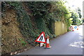
Colway Lane undergoing roadworks
There is an OS benchmark Image on the near end of the wall
Image: © Roger Templeman
Taken: 18 Sep 2012
0.13 miles
5
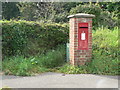
Lyme Regis: postbox № DT7 84, North Avenue
An Elizabeth II-reign box set into a brick pillar.
Image: © Chris Downer
Taken: 27 Sep 2008
0.17 miles
6
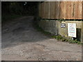
Lyme Regis: driveway to Windy Bottom
A name which conjures up all kinds of image, but not that of campsite!
Image: © Chris Downer
Taken: 27 Sep 2008
0.17 miles
7
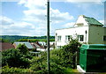
Houses at Colway Lane
The house on the right occupies a sizeable plot on the Charmouth Road the A3052 out of Lyme and it has been there for many decades. Beyond it can be seen houses under construction in Colway Lane.
Image: © Nigel Mykura
Taken: 23 May 2015
0.19 miles
8
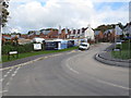
Woodberry Copse, new houses in Lyme Regis
A new development on Woodberry Down Way.
Image: © David Hawgood
Taken: 19 Oct 2016
0.19 miles
9
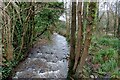
The River Lim on the outskirts of Lyme Regis
The river giving its name to the town
Image: © Tim Heaton
Taken: 7 Feb 2024
0.22 miles
10
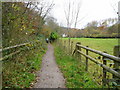
Public Footpath to Uplyme
East Devon Way, Wessex Ridgeway and Liberty Trail leave Lyme Regis.
Image: © Peter Holmes
Taken: 14 Nov 2008
0.22 miles