IMAGES TAKEN NEAR TO
Manor Avenue, LYME REGIS, DT7 3AU
Introduction
This page details the photographs taken nearby to Manor Avenue, DT7 3AU by members of the Geograph project.
The Geograph project started in 2005 with the aim of publishing, organising and preserving representative images for every square kilometre of Great Britain, Ireland and the Isle of Man.

There are currently over 7.5m images from over14,400 individuals and you can help contribute to the project by visiting https://www.geograph.org.uk
Image Map
Images are licensed for reuse under creativecommons.org/licenses/by-sa/2.0
Notes
- Clicking on the map will re-center to the selected point.
- The higher the marker number, the further away the image location is from the centre of the postcode.
Image Listing (48 Images Found)
Images are licensed for reuse under creativecommons.org/licenses/by-sa/2.0
Image
Details
Distance
1
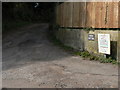
Lyme Regis: driveway to Windy Bottom
A name which conjures up all kinds of image, but not that of campsite!
Image: © Chris Downer
Taken: 27 Sep 2008
0.06 miles
2
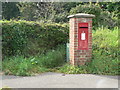
Lyme Regis: postbox № DT7 84, North Avenue
An Elizabeth II-reign box set into a brick pillar.
Image: © Chris Downer
Taken: 27 Sep 2008
0.06 miles
3
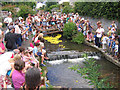
Lyme Regis Duck Race
This was one of the duck races run several times each year in Lyme Regis to raise money for good causes.
The ducks are released into the River Lym, and with a little help from the lifeboat crew when they get stuck, they race downstream to the finish at the Angel pub.
To see some 360°Panoramas of Lyme Regis please visit this http://www.lymepanoramas.eu
Image: © M Etherington
Taken: 28 Jul 2004
0.06 miles
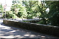
4
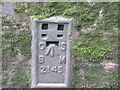
Ordnance Survey Flush Bracket 2145
This can be found on the parapet of Horn Bridge.
For more detail see : http://www.bench-marks.org.uk/bm10127
Image: © Peter Wood
Taken: 2 Apr 2014
0.08 miles
5
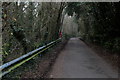
Access Lane to Middle Mill Farm
Leading north from Horne Bridge, and adopted by the Wessex Ridgeway Trail
Image: © Chris Heaton
Taken: 23 Jan 2017
0.08 miles
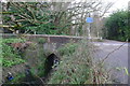
6
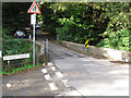
Horne Bridge, Lyme Regis, by Wessex Ridgeway
The bridge crosses the River Lym or Lim. The Wessex Ridgeway runs alongside the river.
Image: © David Hawgood
Taken: 19 Oct 2016
0.08 miles
7
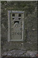
Benchmark on Horn Bridge
Ordnance Survey flush bracket benchmark, serial number 2145, described on the Bench Mark Database at http://www.bench-marks.org.uk/bm10127
Image: © Roger Templeman
Taken: 18 Sep 2012
0.08 miles
8
Colway Lane crosses River Lim at Horne Bridge
Flush Bracket 2145 is on north west face of south east battlement and was levelled with a height of 82.8210 feet (25.2438 metres) above mean sea level (Newlyn datum).
Image: © Peter Holmes
Taken: 14 Nov 2008
0.08 miles
9
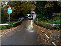
Horn Bridge, Roman Road at Windsor Terrace junction
There is an OS flush Bracket Image on the middle of the bridge parapet
Image: © Roger Templeman
Taken: 18 Sep 2012
0.09 miles
10
'Roman Road' crossing the River Lim
On the Wessex Ridgeway path leaving Lyme Regis
Image: © Tim Heaton
Taken: 23 Jan 2017
0.09 miles