IMAGES TAKEN NEAR TO
Jericho, LYME REGIS, DT7 3AH
Introduction
This page details the photographs taken nearby to Jericho, DT7 3AH by members of the Geograph project.
The Geograph project started in 2005 with the aim of publishing, organising and preserving representative images for every square kilometre of Great Britain, Ireland and the Isle of Man.

There are currently over 7.5m images from over14,400 individuals and you can help contribute to the project by visiting https://www.geograph.org.uk
Image Map
Images are licensed for reuse under creativecommons.org/licenses/by-sa/2.0
Notes
- Clicking on the map will re-center to the selected point.
- The higher the marker number, the further away the image location is from the centre of the postcode.
Image Listing (368 Images Found)
Images are licensed for reuse under creativecommons.org/licenses/by-sa/2.0
Image
Details
Distance
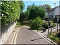
2
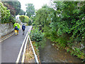
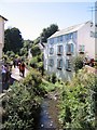
Lyme Regis: the River Lim at the end of Jericho
Looking upstream along the Lim, the river which gives the town its name, in the suburban part of Lyme Regis. The road ahead of us, named Jericho, comes to an abrupt end at the water's edge and the footbridge provides a link to the town centre, a short distance behind us.
Image: © Chris Downer
Taken: 11 Jun 2017
0.00 miles
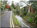
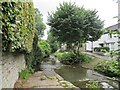
4
Lyme Regis: Jericho reaches the Lim
This short suburban road, named Jericho, runs alongside and then fizzles out at the bank of the River Lim, which gives the town its name. A footbridge to the right provides a route to the town centre, a few hundred yards ahead.
See Image for the view towards us from across the river.
Image: © Chris Downer
Taken: 11 Jun 2017
0.01 miles
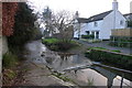
5
Jericho and River Lim, Lyme Regis
Jericho being the name of the lane. At the end the lane ramps down into the river bed, to continue, in principle, as a lengthy ford along the river. These days too many rocks and like have been brought down and not cleared to make a transit even with a horse and cart very tricky.
Image: © Robin Webster
Taken: 19 Jul 2019
0.01 miles
6
Ford on the River Lim, Lyme Regis
Following the river to the sea near the southern end of the Wessex Ridgeway path
Image: © Tim Heaton
Taken: 23 Jan 2017
0.01 miles
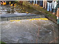
7
The Ford, River Lim - Lyme Regis
This ford is supposed to be the longest in the country. It is situated near Jordan Flats.
Image: © Sarah Smith
Taken: 23 Aug 2021
0.02 miles
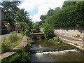
8
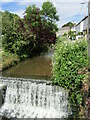
Lyme Regis - Weir
On the River Lim, upstream of the Old Town.
www.lymeregis.org
Image: © Colin Smith
Taken: 20 Jun 2019
0.02 miles
9
The River Lim, sometimes referred to as the River Lym
There is a nice riverside walk here in Lyme Regis.
To see some 360°Panoramas of Lyme Regis please visit this http://www.360panoramas.co.uk/lymeregis
Image: © M Etherington
Taken: 28 Aug 2005
0.02 miles
10
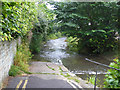
Upstream end of ford down River Lim
The ford is about 90 m long. These days too many rocks and like have been brought down and not cleared to make a transit even with a horse and cart very tricky.
Image: © Robin Webster
Taken: 19 Jul 2019
0.03 miles