IMAGES TAKEN NEAR TO
Charmouth, BRIDPORT, DT6 6RD
Introduction
This page details the photographs taken nearby to DT6 6RD by members of the Geograph project.
The Geograph project started in 2005 with the aim of publishing, organising and preserving representative images for every square kilometre of Great Britain, Ireland and the Isle of Man.

There are currently over 7.5m images from over14,400 individuals and you can help contribute to the project by visiting https://www.geograph.org.uk
Image Map
Images are licensed for reuse under creativecommons.org/licenses/by-sa/2.0
Notes
- Clicking on the map will re-center to the selected point.
- The higher the marker number, the further away the image location is from the centre of the postcode.
Image Listing (10 Images Found)
Images are licensed for reuse under creativecommons.org/licenses/by-sa/2.0
Image
Details
Distance
1
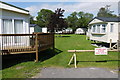
Static Caravans at Bellair
These static caravans are on the Dolphins Caravan Park just outside Charmouth. They are located in the very south eastern corner of the square tucked into the small amount of space between the River Char and the minor road that runs along the Char valley from Charmouth to Whitchurch Canonicorum.
Image: © Nigel Mykura
Taken: 15 Jun 2015
0.05 miles
2
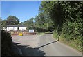
Entrance to Dolphins River Caravan Park
Berne Lane passes the entrance to the park; Image shows a view looking in.
Image: © Derek Harper
Taken: 31 Jul 2015
0.05 miles
3
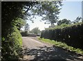
Entrance to Dolphins River Caravan Park
The entrance shown from the opposite direction on Berne Lane to Image
Image: © Derek Harper
Taken: 31 Jul 2015
0.05 miles
4
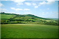
Valley of the Char
Looking north into the river valley from the A35 at the point about half way between Charmouth and Morecombelake. In the background is Coneygar Hill near Wootton Fitzpaine.
Image: © Nigel Mykura
Taken: 23 May 2015
0.09 miles

6
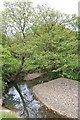
River Char
Side stream near Befferlands Farm
Image: © John Myers
Taken: 27 May 2013
0.17 miles
7
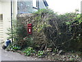
Whitchurch Canonicorum: postbox № DT6 120, Bellair
An Elizabeth II-reign in the southwest corner of the parish of Whitchurch Canonicorum.
Image: © Chris Downer
Taken: 27 Sep 2008
0.18 miles

9
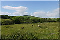
Jacobs Sheep next to the Char
The River Char runs across the middle of the image amongst the trees and bushes just beyond the sheep. The hill in the distance is Coneygar Hill in SY3795 and SY3895
Image: © Nigel Mykura
Taken: 15 Jun 2015
0.20 miles
