IMAGES TAKEN NEAR TO
Fishpond, BRIDPORT, DT6 6NP
Introduction
This page details the photographs taken nearby to Fishpond, DT6 6NP by members of the Geograph project.
The Geograph project started in 2005 with the aim of publishing, organising and preserving representative images for every square kilometre of Great Britain, Ireland and the Isle of Man.

There are currently over 7.5m images from over14,400 individuals and you can help contribute to the project by visiting https://www.geograph.org.uk
Image Map
Images are licensed for reuse under creativecommons.org/licenses/by-sa/2.0
Notes
- Clicking on the map will re-center to the selected point.
- The higher the marker number, the further away the image location is from the centre of the postcode.
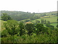
Image Listing (2 Images Found)
Images are licensed for reuse under creativecommons.org/licenses/by-sa/2.0
Image
Details
Distance
1
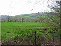
Countryside between Coney's Castle and Fishpond Bottom
The countryside on the edge of the Marshwood Vale is very hilly with narrow lanes. This photograph is taken descending Wootton Hill where there are wonderful views over the hedges. Up on the left is Fishpond Bottom in the next gridsquare.
Image: © Sarah Smith
Taken: 4 Jul 2010
0.23 miles