IMAGES TAKEN NEAR TO
Parkway, BRIDPORT, DT6 6LP
Introduction
This page details the photographs taken nearby to Parkway, DT6 6LP by members of the Geograph project.
The Geograph project started in 2005 with the aim of publishing, organising and preserving representative images for every square kilometre of Great Britain, Ireland and the Isle of Man.

There are currently over 7.5m images from over14,400 individuals and you can help contribute to the project by visiting https://www.geograph.org.uk
Image Map
Images are licensed for reuse under creativecommons.org/licenses/by-sa/2.0
Notes
- Clicking on the map will re-center to the selected point.
- The higher the marker number, the further away the image location is from the centre of the postcode.
Image Listing (259 Images Found)
Images are licensed for reuse under creativecommons.org/licenses/by-sa/2.0
Image
Details
Distance
1
Charmouth, bungalows, semis, villas and apartments
Coastal town in Dorset.
Image: © Peter Barr
Taken: 28 Apr 2013
0.03 miles
2
Hensleigh House, Charmouth
Bed and breakfast accommodation
Image: © Eirian Evans
Taken: 27 May 2019
0.05 miles
3
Charmouth : Hensleigh House B&B
A bed and breakfast on Lower Sea Lane in Charmouth.
Image: © Lewis Clarke
Taken: 6 Jul 2013
0.05 miles
4
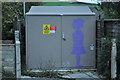
Charmouth : Electricity Substation
On this substation there is a silhouette of a small child. It's located on Lower Sea Lane.
Image: © Lewis Clarke
Taken: 30 Sep 2010
0.05 miles
5
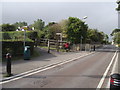
Lower Sea Lane foot path
Next to the footpath is post box No: DT6 64. An earlier photograph by Chris Downer shows it minus its name plate.
Image: © Anthony Vosper
Taken: 3 Sep 2011
0.06 miles
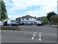
6
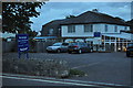
Charmouth : Hensleigh House & Restaurant
Hensleigh house is a hotel, but the tourist board say it can't be called one officially because it doesn't serve food every day of the year.
Image: © Lewis Clarke
Taken: 30 Sep 2010
0.06 miles
7
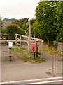
Charmouth: postbox № DT6 64, Lower Sea Lane
The southernmost of Charmouth's five postboxes stands at the end of a footpath from Higher Sea Lane, as it comes out on Lower Sea Lane. Next door to the left is Charmouth Primary School.
Image: © Chris Downer
Taken: 13 Jun 2009
0.06 miles
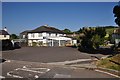
8
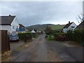
Meadow Way, Charmouth
A private residential road with a view beyond to Stonebarrow Hill
Image: © David Smith
Taken: 15 Jan 2014
0.08 miles
9
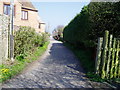
River Way
Public footpath W9/7. Diverted route of South West Coast Path.
Image: © Peter Holmes
Taken: 20 Mar 2009
0.08 miles