IMAGES TAKEN NEAR TO
Hell Lane, BRIDPORT, DT6 6LA
Introduction
This page details the photographs taken nearby to Hell Lane, DT6 6LA by members of the Geograph project.
The Geograph project started in 2005 with the aim of publishing, organising and preserving representative images for every square kilometre of Great Britain, Ireland and the Isle of Man.

There are currently over 7.5m images from over14,400 individuals and you can help contribute to the project by visiting https://www.geograph.org.uk
Image Map
Images are licensed for reuse under creativecommons.org/licenses/by-sa/2.0
Notes
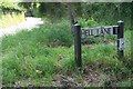
- Clicking on the map will re-center to the selected point.
- The higher the marker number, the further away the image location is from the centre of the postcode.
Image Listing (22 Images Found)
Images are licensed for reuse under creativecommons.org/licenses/by-sa/2.0
Image
Details
Distance
1
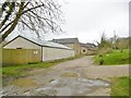
North Chideock, Hell Barn
On Hell Lane; former farm buildings, now self-catering cottages. http://www.hellbarn.co.uk/cottages.asp
Image: © Mike Faherty
Taken: 28 Mar 2017
0.02 miles
2
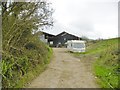
North Chideock, shed
Farm and cattle shed off Hell Lane.
Image: © Mike Faherty
Taken: 28 Mar 2017
0.09 miles
3
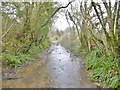
North Chideock, stream
The trickle higher up Hell Lane has become a stream, soon to vanish into a culvert and then join River Winniford.
Image: © Mike Faherty
Taken: 28 Mar 2017
0.10 miles
4
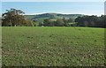
Young crop, North Chideock
Another view across the field shown in Image], with overlap. The path goes rather to the left of this image, which is looking towards Hell Farm. Beyond is Quarry Hill.
Image: © Derek Harper
Taken: 31 Oct 2015
0.10 miles
5
Looking west along Hell Lane
A country lane at North Chideock
To see some 360° Panoramas of Dorset please visit this http://www.360panoramas.co.uk
Image: © M Etherington
Taken: 18 Apr 2007
0.11 miles
6
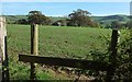
Crop across footpath, North Chideock
I had been intending to go to Hell - Hell Lane, that is, which is where footpath W10 3 leads from this stile. But the farmer hasn't bothered to restore the path, rather like a lazy Charon reluctant to do any ferrying across the Styx to the Underworld, and I can't be bothered to traipse around the edge of the field, so, I'll go another way. I guess this is winter wheat.
Image: © Derek Harper
Taken: 31 Oct 2015
0.16 miles
7
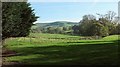
Countryside, North Chideock
From the no through road (dividing into a total of four no through roads) through the hamlet, looking towards Quarry Hill.
Image: © Derek Harper
Taken: 31 Oct 2015
0.20 miles
8
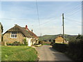
Cottages and overhead wires at North Chideock
A view of attractive thatched buildings in North Chideock, looking east along the road leading to Brighthay and Wells Farms, which for some reason becomes 'Hell lane' a bit further along.
Image: © Stephen Williams
Taken: 6 Apr 2007
0.20 miles
9
Hell Lane, North Chideock
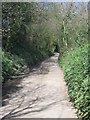
A delightful name for what turns into a dark and dingy holloway!
Image: © Becky Williamson
Taken: 27 Jul 2017
0.20 miles
10
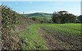
Young crop, North Chideock
This is the north edge of the field shown in Image], seen from just over Hell Lane behind the camera in Image Actually only the first 50 metres of this view are in this square; the remainder is in Image On the horizon is Quarry Hill.
Image: © Derek Harper
Taken: 31 Oct 2015
0.20 miles