IMAGES TAKEN NEAR TO
Broadmead, BRIDPORT, DT6 6HU
Introduction
This page details the photographs taken nearby to Broadmead, DT6 6HU by members of the Geograph project.
The Geograph project started in 2005 with the aim of publishing, organising and preserving representative images for every square kilometre of Great Britain, Ireland and the Isle of Man.

There are currently over 7.5m images from over14,400 individuals and you can help contribute to the project by visiting https://www.geograph.org.uk
Image Map
Images are licensed for reuse under creativecommons.org/licenses/by-sa/2.0
Notes
- Clicking on the map will re-center to the selected point.
- The higher the marker number, the further away the image location is from the centre of the postcode.
Image Listing (40 Images Found)
Images are licensed for reuse under creativecommons.org/licenses/by-sa/2.0
Image
Details
Distance
1
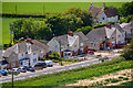
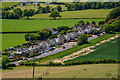
Chideock : Main Street
Looking down towards houses on Main Street.
Image: © Lewis Clarke
Taken: 26 May 2020
0.00 miles
2
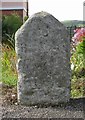
Old Milestone by the A35, east of Chideock
Carved stone post by the A35, in parish of CHIDEOCK (WEST DORSET District), by 'The Pods'; opposite bus shelter, on South side of road. Dorset 1 (limestone), erected by the Bridport - First District turnpike trust in the 19th century.
Inscription reads:-
2
Bridport
10
(Axminster)
Rivet on top, benchmark not visible.
Milestone Society National ID: DO_AXBP10
Image: © Mike Faherty
Taken: 17 Aug 2008
0.01 miles
3
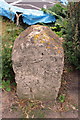
Milestone at Broadmead, Chideock
The stone has an Ordnance Survey rivet benchmark http://www.bench-marks.org.uk/bm25821 which is shown on the 1889 map as a benchmark at 115.1 ft. above Liverpool Datum. The stone recorded Bridport 2, Axminster 10 but much of the wording is now indistinct.
Image: © Roger Templeman
Taken: 9 Sep 2012
0.01 miles
4
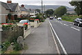
Chideock : Main Street
Houses along Main Street in Chideock.
Image: © Lewis Clarke
Taken: 26 May 2020
0.01 miles
5
Chideock : Main Street
Looking down to Main Street and houses on the outskirts of Chideock.
Image: © Lewis Clarke
Taken: 26 May 2020
0.01 miles
6
A35 outside Broadmead houses, The Street
The old milestone in the left foreground has an OS benchmark Image in the form of a rivet on its top.
Image: © Roger Templeman
Taken: 9 Sep 2012
0.02 miles
7
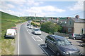
Traffic Entering Chideock
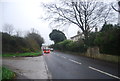
Looking east along the A35 at the eastern entrance to the village. Chideock is a renowned black spot for traffic congestion particularly in the summer with heavy tourist traffic.
Image: © Nigel Mykura
Taken: 23 May 2015
0.05 miles
8
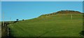
Slopes of Quarry Hill
From the A35 looking up the southwest slopes, across a steep hillside field the upper part of which is crossed by footpath W10 7.
Image: © Derek Harper
Taken: 31 Oct 2015
0.08 miles
9
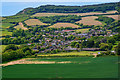
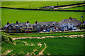
Chideock : Chideock Scenery
Looking across the fields and into the village.
Image: © Lewis Clarke
Taken: 26 May 2020
0.09 miles