IMAGES TAKEN NEAR TO
Verriotts Lane, BRIDPORT, DT6 6DU
Introduction
This page details the photographs taken nearby to Verriotts Lane, DT6 6DU by members of the Geograph project.
The Geograph project started in 2005 with the aim of publishing, organising and preserving representative images for every square kilometre of Great Britain, Ireland and the Isle of Man.

There are currently over 7.5m images from over14,400 individuals and you can help contribute to the project by visiting https://www.geograph.org.uk
Image Map (Loading...)


Getting Data...Please wait
Leaflet Map data © OpenStreetMap
Images are licensed for reuse under creativecommons.org/licenses/by-sa/2.0
Notes
- Clicking on the map will re-center to the selected point.
- The higher the marker number, the further away the image location is from the centre of the postcode.
Image Listing (35 Images Found)
Images are licensed for reuse under creativecommons.org/licenses/by-sa/2.0
Image
Details
Distance
1
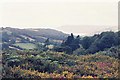
Hardown Hill: view west
Looking towards the Devon coast.
Image: © Chris Downer
Taken: 26 Aug 1994
0.06 miles
3
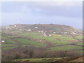
On Hardown Hill
In the vicinity of the top of the hill
Image: © Michael Graham
Taken: 29 Aug 2013
0.14 miles
5
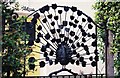
Morcombelake: ironwork peacock
An ornamental front gate in Morcombelake.
Image: © Chris Downer
Taken: 26 Aug 1994
0.15 miles
6
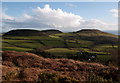
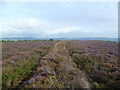
Gorse and dead bracken on Hardown Hill
The image was taken south of the summit area of Hardown Hill over the southern limit of access land there. The distant hills are Langdon Hill, (which has the appearance of being two wooded hills), and Golden Cap.
Image: © Trevor Littlewood
Taken: 9 Mar 2008
0.16 miles
7

Morcombelake: Love?s Lane
A little lane off Pitman Lane, with a rather pleasant, possibly eponymous name.
Image: © Chris Downer
Taken: 13 Jun 2009
0.16 miles
8
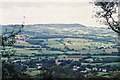
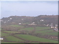
Hardown Hill: view northwest
Looking over the village of Whitechurch Canonicorum – the Image can be seen in the foreground.
Image: © Chris Downer
Taken: 26 Aug 1994
0.17 miles
10
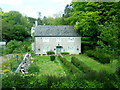
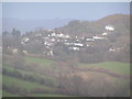
House at Morcombelake
This nicely proportioned house is et back from the A35 which passes through the middle of the village. It is next to one of the bus stops in the village.
Image: © Nigel Mykura
Taken: 23 May 2015
0.17 miles