IMAGES TAKEN NEAR TO
Monkton Wyld, BRIDPORT, DT6 6DD
Introduction
This page details the photographs taken nearby to DT6 6DD by members of the Geograph project.
The Geograph project started in 2005 with the aim of publishing, organising and preserving representative images for every square kilometre of Great Britain, Ireland and the Isle of Man.

There are currently over 7.5m images from over14,400 individuals and you can help contribute to the project by visiting https://www.geograph.org.uk
Image Map
Images are licensed for reuse under creativecommons.org/licenses/by-sa/2.0
Notes
- Clicking on the map will re-center to the selected point.
- The higher the marker number, the further away the image location is from the centre of the postcode.
Image Listing (12 Images Found)
Images are licensed for reuse under creativecommons.org/licenses/by-sa/2.0
Image
Details
Distance
1
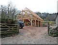
New timber construction on Pound Lane
Image: © Roger Cornfoot
Taken: 13 Apr 2021
0.09 miles
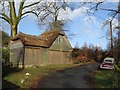
3
Forest Farm, Highgate, West Dorset
This is just north of Monkton Wyld, West Dorset
Image: © Stuart Buchan
Taken: 12 May 2006
0.13 miles
4
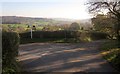
Pound Lane
A rainbow of sun forces its way through the lens, as I try to take a shot against the light down the lane from the junction shown in Image Round the bend is a turn into Forest Farm.
Image: © Derek Harper
Taken: 23 Nov 2013
0.15 miles
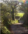
5
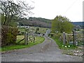
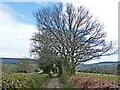
Pound Lane
Bridleway W20/32 leaves the lane on the left as it winds down into a valley. The bridleway goes past Higher Pound Farm.
Image: © Derek Harper
Taken: 23 Nov 2013
0.17 miles
6
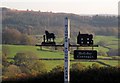
Sign at Higher Pound Farm
The sign can also be seen in Image]; it is at the start of bridleway W20/32 which goes past the farm.
Image: © Derek Harper
Taken: 23 Nov 2013
0.17 miles
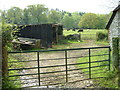
8
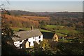
Lower Pound Farm
From the junction shown in Image The wood on the left is Wyld Warren and the further woodland is on Wootton Hill.
Image: © Derek Harper
Taken: 23 Nov 2013
0.20 miles
10
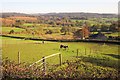
Higher Pound Farm
From Pound Lane. The farmhouse is described at http://list.english-heritage.org.uk/resultsingle.aspx?uid=1279351&searchtype=mapsearch . The view extends over Wyld Warren and the headwater valleys of a tributary of the Char.
Image: © Derek Harper
Taken: 23 Nov 2013
0.22 miles