IMAGES TAKEN NEAR TO
Eype, BRIDPORT, DT6 6AL
Introduction
This page details the photographs taken nearby to DT6 6AL by members of the Geograph project.
The Geograph project started in 2005 with the aim of publishing, organising and preserving representative images for every square kilometre of Great Britain, Ireland and the Isle of Man.

There are currently over 7.5m images from over14,400 individuals and you can help contribute to the project by visiting https://www.geograph.org.uk
Image Map
Images are licensed for reuse under creativecommons.org/licenses/by-sa/2.0
Notes
- Clicking on the map will re-center to the selected point.
- The higher the marker number, the further away the image location is from the centre of the postcode.
Image Listing (84 Images Found)
Images are licensed for reuse under creativecommons.org/licenses/by-sa/2.0
Image
Details
Distance
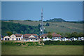
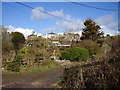
2
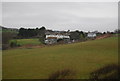
Lower Eype
A view from Highlands End of Lower Eype, Eype's Mouth Country Hotel being just right of centre. Eype Mouth beach is down to the left whilst the hills rise up to Thorncombe Beacon at the highest point on the right.
Image: © John Stephen
Taken: 20 Apr 2015
0.01 miles
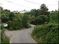
3
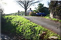
Entrance drive to 'Seabreeze' and 'Bonville'
There is an OS benchmark Image on the near end of the concrete wall to the right of the car
Image: © Roger Templeman
Taken: 6 Nov 2016
0.04 miles
4
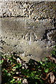
Benchmark at entrance to 'Seabreeze', Mount Lane
Ordnance Survey cut mark benchmark described on the Bench Mark Database at http://www.bench-marks.org.uk/bm80262
Image: © Roger Templeman
Taken: 6 Nov 2016
0.04 miles
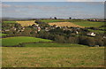
5
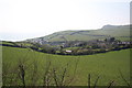
Symondsbury : Lower Eype Scenery
Looking across towards Lower Eype.
Image: © Lewis Clarke
Taken: 26 May 2020
0.05 miles
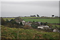
7
Symondsbury : Lower Eype Scenery
Looking down into the hamlet of Lower Eype.
Image: © Lewis Clarke
Taken: 26 May 2020
0.06 miles
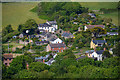
8
Lower Eype
Viewed from the stretch of the Monarch's Way shown in Image The village is strung out along a west-facing hillside just inland from Eype Mouth. At top right is part of Highlands End Holiday Park.
Image: © Derek Harper
Taken: 29 Sep 2012
0.06 miles
9
Interesting accommodation
This guest house offers something slightly different to stay in.
A converted railway carriage.
Image: © Anthony Vosper
Taken: 4 Mar 2016
0.08 miles
10
A converted railway carriage
Just a bend in the lane at Eype until I saw the outline of an old Railway Carriage, now used for accommodation it seems.
Image: © Ant Basterfield
Taken: 8 Jul 2015
0.08 miles