IMAGES TAKEN NEAR TO
West Road, BRIDPORT, DT6 6AE
Introduction
This page details the photographs taken nearby to West Road, DT6 6AE by members of the Geograph project.
The Geograph project started in 2005 with the aim of publishing, organising and preserving representative images for every square kilometre of Great Britain, Ireland and the Isle of Man.

There are currently over 7.5m images from over14,400 individuals and you can help contribute to the project by visiting https://www.geograph.org.uk
Image Map
Images are licensed for reuse under creativecommons.org/licenses/by-sa/2.0
Notes
- Clicking on the map will re-center to the selected point.
- The higher the marker number, the further away the image location is from the centre of the postcode.
Image Listing (15 Images Found)
Images are licensed for reuse under creativecommons.org/licenses/by-sa/2.0
Image
Details
Distance
1
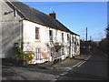
Post Box House, Symondsbury
Formerly the London Inn.
Image: © Roger Cornfoot
Taken: 17 Nov 2009
0.04 miles
2
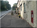
Symondsbury: postbox № DT6 44, West Road
A George V-reign postbox set into the wall of the Image on the A35.
Image: © Chris Downer
Taken: 27 Sep 2008
0.04 miles
3
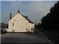
Symondsbury: former London Inn
The pub closed about 15 years ago and it is now called Post Box House because there is a postbox set into the front wall.
Image: © Chris Downer
Taken: 27 Sep 2008
0.06 miles
4
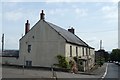
The former London Inn, West Road (A35)
Now a private house beside the A35
Image: © David Smith
Taken: 8 Jul 2019
0.06 miles
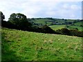
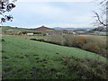
5

Symondsbury: fields below Colmer?s Hill
A public footpath crosses the field in the immediate foreground. Beyond, the distinctive backdrop of Colmer’s Hill.
Image: © Chris Downer
Taken: 27 Sep 2008
0.10 miles
6
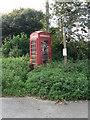
Symondsbury: phone box by old London Inn
This phone box, with somewhat nettly access path, is by the Image on the A35.
Image: © Chris Downer
Taken: 27 Sep 2008
0.10 miles
7
Miles Cross
View NW across the NW corner of the square just north of the A35
Image: © Nigel Mykura
Taken: 18 Sep 2008
0.13 miles
8
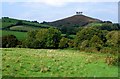
Miles Cross
View North across the NW corner of the square near West Hill. In the distance is the distinctive shape of Colmer's Hill in SY4493
Image: © Nigel Mykura
Taken: 18 Sep 2008
0.13 miles
9
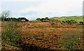
Tumulus, Eype Down
Not a very good quality enlargement of the main photograph, showing what I believe is the tumulus marked on the OS map.
Image: © Ralph Mills
Taken: 16 Feb 2006
0.16 miles
10
Farmland and houses north of Eype Down Lane
The houses are beside West Road (A35),near the former London Inn. Colmer's Hill in the squares to the north and north-west and Lewesdon Hill on the skyline can also be seen.
Image: © Maurice D Budden
Taken: 24 Nov 2014
0.16 miles