IMAGES TAKEN NEAR TO
Queens Walk, BRIDPORT, DT6 6AB
Introduction
This page details the photographs taken nearby to Queens Walk, DT6 6AB by members of the Geograph project.
The Geograph project started in 2005 with the aim of publishing, organising and preserving representative images for every square kilometre of Great Britain, Ireland and the Isle of Man.

There are currently over 7.5m images from over14,400 individuals and you can help contribute to the project by visiting https://www.geograph.org.uk
Image Map
Images are licensed for reuse under creativecommons.org/licenses/by-sa/2.0
Notes
- Clicking on the map will re-center to the selected point.
- The higher the marker number, the further away the image location is from the centre of the postcode.
Image Listing (132 Images Found)
Images are licensed for reuse under creativecommons.org/licenses/by-sa/2.0
Image
Details
Distance
1
The Queen's Armes Hotel, Charmouth
King Charles II, fleeing from the Battle of Worcester, spent the night of 22 September 1651, in the Queen's Armes. He was hoping to take passage on a boat to France but his plans unraveled and he had to take flight inland.
The hotel is currently being converted into holiday flats. Another couple of coats of paint will hide the hotel name. Image A sign reports that Catherine of Aragon stayed here in 1501.
Image: © John M
Taken: 26 Feb 2008
0.02 miles
2
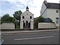
Charmouth United Reformed Church
The date stone over the doorway records the churches original construction date
1689 and then a number of rebuilds and restorations.
Image: © Anthony Vosper
Taken: 3 Sep 2011
0.02 miles
3
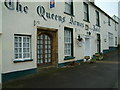
Queens Armes Hotel, Charmouth
Catherine of Aragon stayed here in 1501, and King Charles II slept here in 1651 according to the notice on the main door.
Image: © Robin Lucas
Taken: 7 Dec 2005
0.03 miles
4
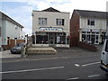
The Old Bank Cafe
Situated on The Street.
Image: © Anthony Vosper
Taken: 3 Sep 2011
0.04 miles
5
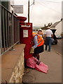
Charmouth: postbox № DT6 24, The Street
The post-lady has just collected mail from the post office, two doors away, this Saturday lunchtime and is now emptying the postbox almost an hour later than the advertised Saturday last-collection time of 11:30. The weekday time is advertised as 4:45pm.
Image: © Chris Downer
Taken: 13 Jun 2009
0.04 miles
6

Charmouth : The Street
The Street heads up the hill from here.
Image: © Lewis Clarke
Taken: 6 Jul 2013
0.04 miles
7
Devenedge Hotel, The Street
There is an OS flush bracket (serial number G3239) http://www.facebook.com/photo.php?fbid=4287336104295&l=b0f5da02b6 on the side of the building near the junction with its front wall.
Image: © Roger Templeman
Taken: 9 Sep 2012
0.05 miles
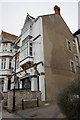
8

Fading glory
Now shops and flats this was once the aptly named Devonedge Hotel.
An OS flush bracket can be located on the side wall in Lansdowne Court.
Image: © Anthony Vosper
Taken: 3 Sep 2011
0.05 miles
9
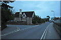
Charmouth : Lower Sea Lane
Lower Sea Lane in Charmouth with the road Wesley Close on the left.
Image: © Lewis Clarke
Taken: 30 Sep 2010
0.05 miles
10
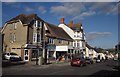
The Street, Charmouth
Looking in the other direction from the same spot as Image The Monarch's Way goes up Barr's Lane on the left past the white car. Next to this is the post office, an estate agent, and a general store ("newsagents, confectionery, beach goods, gifts, greeting cards, stationery, hardware, gardening and a whole lot more" http://www.charmouth-dorset.co.uk/?page_id=38 ). Then comes the former Devonedge Hotel - see Image
Image: © Derek Harper
Taken: 29 Sep 2012
0.05 miles