IMAGES TAKEN NEAR TO
Mead Fields, BRIDPORT, DT6 5RE
Introduction
This page details the photographs taken nearby to Mead Fields, DT6 5RE by members of the Geograph project.
The Geograph project started in 2005 with the aim of publishing, organising and preserving representative images for every square kilometre of Great Britain, Ireland and the Isle of Man.

There are currently over 7.5m images from over14,400 individuals and you can help contribute to the project by visiting https://www.geograph.org.uk
Image Map
Images are licensed for reuse under creativecommons.org/licenses/by-sa/2.0
Notes
- Clicking on the map will re-center to the selected point.
- The higher the marker number, the further away the image location is from the centre of the postcode.
Image Listing (55 Images Found)
Images are licensed for reuse under creativecommons.org/licenses/by-sa/2.0
Image
Details
Distance
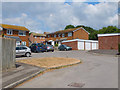
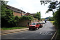
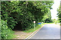
2
Mead Fields, Allington
View from Hospital Lane.
Image: © John Stephen
Taken: 24 Jun 2015
0.06 miles
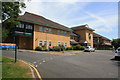
3
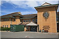
Bridport Community Hospital Main Entrance
Image: © John Stephen
Taken: 24 Jun 2015
0.07 miles
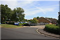
4
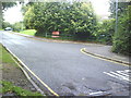
Approach road and path to Bridport Hospital
Image: © Roger Templeman
Taken: 23 Sep 2010
0.07 miles
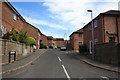
5
Hospital Lane
View down Hospital Lane from where Mead Lane comes out looking towards North Allington.
Image: © John Stephen
Taken: 24 Jun 2015
0.07 miles
7
Greenfields Day Hospital
Greenfields is a day hospital on the Community Hospital site providing care for older people who have an organic mental health problem such as Dementia, Cerebral Vascular Disease etc. The symptoms of patients attending usually present as memory problems, confusion, wandering and some behavioural difficulties.
It used to be a mental health centre offering overnight psychiatric care, called the Hughes unit, but services were "rationalised" so the nearest is now at least 14 miles away. Care in the Community.
Image: © John Stephen
Taken: 24 Jun 2015
0.08 miles
8
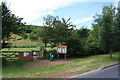
Gate onto Allington Hill
Parish Council notice board on Hospital Lane and gate access to Allington Hill. Allington Hill has wooded slopes and top under protection of the Woodland Trust whilst the lower slopes are managed by a local community project calling itself the "Allington Hillbillies" with support from the local Parish Council.
Image: © John Stephen
Taken: 24 Jun 2015
0.08 miles
9
Hospital Lane and Mead Lane
Hospital Lane is the tarmac road running, predictably, up to Bridport Community Hospital. Mead Lane forks off to the left.
Image: © John Stephen
Taken: 24 Jun 2015
0.08 miles
10

Bridport Community Hospital from Allington Hill
Image: © Maurice D Budden
Taken: 1 Jun 2006
0.08 miles