IMAGES TAKEN NEAR TO
De Legh Grove, BRIDPORT, DT6 5QY
Introduction
This page details the photographs taken nearby to De Legh Grove, DT6 5QY by members of the Geograph project.
The Geograph project started in 2005 with the aim of publishing, organising and preserving representative images for every square kilometre of Great Britain, Ireland and the Isle of Man.

There are currently over 7.5m images from over14,400 individuals and you can help contribute to the project by visiting https://www.geograph.org.uk
Image Map
Images are licensed for reuse under creativecommons.org/licenses/by-sa/2.0
Notes
- Clicking on the map will re-center to the selected point.
- The higher the marker number, the further away the image location is from the centre of the postcode.
Image Listing (122 Images Found)
Images are licensed for reuse under creativecommons.org/licenses/by-sa/2.0
Image
Details
Distance
2
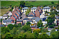
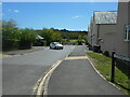
Lodge Lane, Bridport
A cul-de-sac of modern houses that leads to a few others, on the slopes of Allington Hill.
Image: © Derek Harper
Taken: 31 Oct 2015
0.05 miles
3
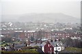
Bridport : Bridport Scenery
Looking towards houses on the suburbs of Bridport.
Image: © Lewis Clarke
Taken: 26 May 2020
0.06 miles
4
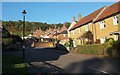
West Allington looking west
View west along West Allington/West Road with the Medical Centre on the left followed by the almost finished Symene Community Land Trust Housing and then West Road Garage.
Image: © John Stephen
Taken: 18 Jan 2015
0.07 miles
5
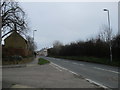
West Allington, the B3162 into Bridport from the west
Lodge Lane on the left.
Image: © John Stephen
Taken: 15 Mar 2018
0.07 miles
6
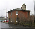
Old Toll House by West Road, Bridport
Toll House by the B3162, in the parish of Bridport (West Dorset District), Turnpike Cottage, West Road, DT6 6AG.
Grade II listed.
List Entry Number: 1228712 https://historicengland.org.uk/listing/the-list/list-entry/1228712
Surveyed
Milestone Society National ID: DO.BRI01
Image: © Alan Rosevear
Taken: Unknown
0.07 miles
7
Symene Community Land Trust, West Road
View of the small development of affordable housing for local people on West Road, West Allington. The not-for-profit Hastoe Housing Association is working in partnership with West Dorset District Council, C G Fry the local builders and the Symene Community Land Trust to deliver the homes. They were originally to be built in Symondsbury parish but suitable land couldn't be acquired, so they are just inside Allington
The houses are being built specifically for people with a connection to the area; it is a welcome move in an area where most new development is unaffordable by locals and becomes retirement or second homes. There are only ten houses in total, but at least it's a start. 6 are two-bedroom, 3 three-bedroom and 1 four-bedroom. One of the two-bedroom and one of the three-bedroom houses will be shared equity with the others being for rent.
Image: © John Stephen
Taken: 18 Jan 2015
0.07 miles
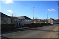
8
Edwards Close
To the left is the Ammonite Health Centre.
One of Bridport's Covid 19 vaccination points.
Image: © Anthony Vosper
Taken: 19 May 2021
0.08 miles
9
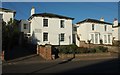
Villas, Bridport
A row of four stucco villas dating from the 1830s on West Allington (the B3162), each of them listed. On the left is a glimpse of Allington Lodge http://www.historicengland.org.uk/listing/the-list/list-entry/1228570 ; then Drayton Lodge http://www.historicengland.org.uk/listing/the-list/list-entry/1279465 ; Avalon http://www.historicengland.org.uk/listing/the-list/list-entry/1228568 and Ivydene http://www.historicengland.org.uk/listing/the-list/list-entry/1228567 .
Image: © Derek Harper
Taken: 31 Oct 2015
0.09 miles
10
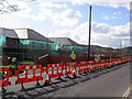
Bridport's new Health Centre
Work continuing on the new health centre in West Road, Bridport.
Image: © Stephen Williams
Taken: 13 Mar 2007
0.09 miles