IMAGES TAKEN NEAR TO
Pymore, BRIDPORT, DT6 5PR
Introduction
This page details the photographs taken nearby to DT6 5PR by members of the Geograph project.
The Geograph project started in 2005 with the aim of publishing, organising and preserving representative images for every square kilometre of Great Britain, Ireland and the Isle of Man.

There are currently over 7.5m images from over14,400 individuals and you can help contribute to the project by visiting https://www.geograph.org.uk
Image Map
Images are licensed for reuse under creativecommons.org/licenses/by-sa/2.0
Notes
- Clicking on the map will re-center to the selected point.
- The higher the marker number, the further away the image location is from the centre of the postcode.
Image Listing (12 Images Found)
Images are licensed for reuse under creativecommons.org/licenses/by-sa/2.0
Image
Details
Distance
1
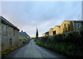
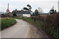
Higher Pymore Farm
The farm is a mixed stock and arable farm and sits on Pymore Lane between Wooth and Dottery.
Image: © Nigel Mykura
Taken: 29 Dec 2015
0.07 miles
2
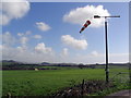
Bridport (Pymore) International Airport
This is a small farm airstrip on the flattish hilltop between Higher Pymore Farm and Middle Pymore Farm. The mown landing strip can be seen, along with the windsock, and some aircraft are hangared here. On this particular day the only movements were a couple of radio-controlled models, one of which is seen being landed by the operator who is standing beyond the windsock pole.
Image: © Stephen Williams
Taken: 6 Mar 2007
0.08 miles
3
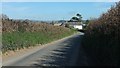
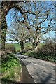
Higher Pymore Farm
Seen along Pymore Lane, which also carries NCN2 and the parish boundary between Allington (right) and Netherbury.
Image: © Derek Harper
Taken: 12 Apr 2016
0.08 miles
4

Pymore Lane
At the junction with the entrance to Middle Pymore Farm on the right, a track used by bridleway W3 6, leading to the Monarch's Way.
Image: © Derek Harper
Taken: 12 Apr 2016
0.09 miles
5
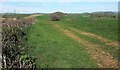
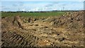
Farmland by Pymore Lane
Taken parallel to Image, with the right-hand hedgebank on the left here, looking towards the valley of a tributary of the Brit.
Image: © Derek Harper
Taken: 12 Apr 2016
0.10 miles
6
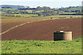
Farmland near Lower Ash
I think that the concrete structure is for water storage.
Image: © Andy Stephenson
Taken: 18 Oct 2007
0.11 miles
7

Hardy Way near Dottery
Very overgrown bridleway near the small hamlet of Dottery.
Image: © Becky Williamson
Taken: 2 Aug 2018
0.11 miles
8
Farmland by Pymore Lane
The view across the lane from Image], with Higher Ash Farm in the distance.
Image: © Derek Harper
Taken: 12 Apr 2016
0.12 miles
9
Pymore Lane at the approach to Upper Pymore Farm
Image: © Roger Templeman
Taken: 20 Feb 2011
0.13 miles
10
Pymore Lane
This land carries NCN2 and also, as far as the stream crossing just ahead, the parish boundary between Allington (right) and Netherbury.
Image: © Derek Harper
Taken: 12 Apr 2016
0.21 miles