IMAGES TAKEN NEAR TO
St. James Road, BRIDPORT, DT6 5LW
Introduction
This page details the photographs taken nearby to St. James Road, DT6 5LW by members of the Geograph project.
The Geograph project started in 2005 with the aim of publishing, organising and preserving representative images for every square kilometre of Great Britain, Ireland and the Isle of Man.

There are currently over 7.5m images from over14,400 individuals and you can help contribute to the project by visiting https://www.geograph.org.uk
Image Map
Images are licensed for reuse under creativecommons.org/licenses/by-sa/2.0
Notes
- Clicking on the map will re-center to the selected point.
- The higher the marker number, the further away the image location is from the centre of the postcode.
Image Listing (32 Images Found)
Images are licensed for reuse under creativecommons.org/licenses/by-sa/2.0
Image
Details
Distance
1
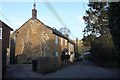
Bridge Street, Netherbury
Dormouse Cottage, the first of the cottages on the left, is listed and described at https://www.historicengland.org.uk/listing/the-list/list-entry/1215612 .
Image: © Derek Harper
Taken: 12 Apr 2016
0.10 miles
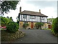
2
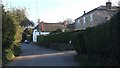
St James Road, Netherbury
A pair of old houses, but only Laurel Farmhouse, on the right, is listed https://www.historicengland.org.uk/listing/the-list/list-entry/1287834 . The thatched cottages is half of Yew Tree Cottages.
Image: © Derek Harper
Taken: 12 Apr 2016
0.10 miles
4
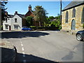
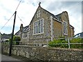
Netherbury Square
The white building was,in the 1960s, a shop. At that time there was a second shop in the village, combined with a post office, now a private residence. There were also two pubs and a school, all long closed.
Image: © Maurice D Budden
Taken: 4 Jun 2013
0.14 miles
5
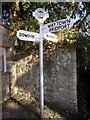
Netherbury: finger-post at The Square
The signpost has been tidied up since Google imagery in September 2011, and also had added a traditional style finial giving location name and grid reference - see Image for a close-up.
Image: © Chris Downer
Taken: 10 Mar 2015
0.14 miles
6
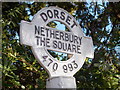
Netherbury: finger-post detail
A closer look at the traditional (but replica) roundel atop the signpost in the village centre. It gives the location name and six-digit grid reference.
The whole signpost is seen here: Image
Image: © Chris Downer
Taken: 10 Mar 2015
0.14 miles
7
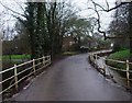
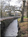
Bridge Street running into Netherbury
Standing on the bridge over the River Brit
Image: © Tim Heaton
Taken: 28 Jan 2013
0.14 miles
9

Netherbury: postbox № DT6 76 and phone
These two red objects stand, alongside a shelter, at the crossroads in the centre of the village. The postbox is emptied finally at 4:45pm on weekdays and at 10am on Saturdays.
Image: © Chris Downer
Taken: 3 Apr 2010
0.14 miles