IMAGES TAKEN NEAR TO
Waytown, BRIDPORT, DT6 5LQ
Introduction
This page details the photographs taken nearby to DT6 5LQ by members of the Geograph project.
The Geograph project started in 2005 with the aim of publishing, organising and preserving representative images for every square kilometre of Great Britain, Ireland and the Isle of Man.

There are currently over 7.5m images from over14,400 individuals and you can help contribute to the project by visiting https://www.geograph.org.uk
Image Map
Images are licensed for reuse under creativecommons.org/licenses/by-sa/2.0
Notes
- Clicking on the map will re-center to the selected point.
- The higher the marker number, the further away the image location is from the centre of the postcode.
Image Listing (8 Images Found)
Images are licensed for reuse under creativecommons.org/licenses/by-sa/2.0
Image
Details
Distance
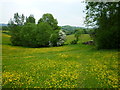
2

Slape Hill
Dropping gently from the spot where Image] and Image] were taken, but increasingly steep as it approaches Slape manor.
Image: © Derek Harper
Taken: 12 Apr 2016
0.14 miles
4
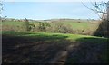
Towards the Brit
From Slape Hill near Slape Farm.
Image: © Derek Harper
Taken: 12 Apr 2016
0.17 miles
6

Waytown: postbox № DT6 25
This Victorian postbox faces the lane leading to Melplash, and is emptied each morning except Sunday at 9 o'clock.
Image: © Chris Downer
Taken: 12 Sep 2009
0.20 miles
7
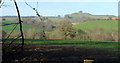
Across the Brit
From the same spot as Image], looking left with some overlap. The famous River Cottage is somewhere down there by the Brit. The prominent hill is South Warren Hill.
Image: © Derek Harper
Taken: 12 Apr 2016
0.21 miles
8
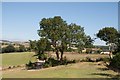
Looking towards Patley Wood Farm from bridleway
Image: © Becky Williamson
Taken: 2 Aug 2018
0.23 miles