IMAGES TAKEN NEAR TO
Waytown, BRIDPORT, DT6 5LF
Introduction
This page details the photographs taken nearby to DT6 5LF by members of the Geograph project.
The Geograph project started in 2005 with the aim of publishing, organising and preserving representative images for every square kilometre of Great Britain, Ireland and the Isle of Man.

There are currently over 7.5m images from over14,400 individuals and you can help contribute to the project by visiting https://www.geograph.org.uk
Image Map
Images are licensed for reuse under creativecommons.org/licenses/by-sa/2.0
Notes
- Clicking on the map will re-center to the selected point.
- The higher the marker number, the further away the image location is from the centre of the postcode.
Image Listing (3 Images Found)
Images are licensed for reuse under creativecommons.org/licenses/by-sa/2.0
Image
Details
Distance
2
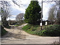
Entrance to Elwell Farms, near Waytown
This is the main entrance to Elwell Farms. The signs advertise a cattery and boarding kennels, and an ostrich was strutting around the paddock at the fork in the track.
Image: © Stephen Williams
Taken: 26 Feb 2007
0.04 miles
3
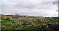
Fields near Waytown, looking south east
This is taken from a field entrance near Elwell Lodge on the road between Waytown and Lambrook and is a view across the Brit valley towards Mangerton.
Image: © Stephen Williams
Taken: 26 Feb 2007
0.23 miles