IMAGES TAKEN NEAR TO
Salwayash, BRIDPORT, DT6 5HT
Introduction
This page details the photographs taken nearby to DT6 5HT by members of the Geograph project.
The Geograph project started in 2005 with the aim of publishing, organising and preserving representative images for every square kilometre of Great Britain, Ireland and the Isle of Man.

There are currently over 7.5m images from over14,400 individuals and you can help contribute to the project by visiting https://www.geograph.org.uk
Image Map (Loading...)


Getting Data...Please wait
Leaflet Map data © OpenStreetMap
Images are licensed for reuse under creativecommons.org/licenses/by-sa/2.0
Notes
- Clicking on the map will re-center to the selected point.
- The higher the marker number, the further away the image location is from the centre of the postcode.
Image Listing (5 Images Found)
Images are licensed for reuse under creativecommons.org/licenses/by-sa/2.0
Image
Details
Distance
1
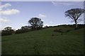
Salwayash
Salway Ash is a rather straggly, ill-defined village with houses, school and church strung out over a considerable length of the Bridport to Broadwindsor road. These are a few of the houses at the lower end of the village close to Paverlands Farm and Broadenham Farm.
Image: © Nigel Mykura
Taken: 29 Dec 2015
0.11 miles
2
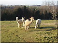
Alpacas grazing
Alpacas are South American animals, related but smaller than llamas, which have been prized for their wool for centuries. There are several herds in the Somerset and Devon areas. This group was spotted at Salwayash and didn't seem too bothered by having their photographs taken.
Image: © David Williams
Taken: 11 Dec 2010
0.17 miles
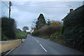
4
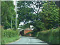
B3162 north of Dottery
Approaching Ashleigh Farm
Image: © Chris Gunns
Taken: 5 Jun 2019
0.22 miles