IMAGES TAKEN NEAR TO
St. Swithins Avenue, BRIDPORT, DT6 5DN
Introduction
This page details the photographs taken nearby to St. Swithins Avenue, DT6 5DN by members of the Geograph project.
The Geograph project started in 2005 with the aim of publishing, organising and preserving representative images for every square kilometre of Great Britain, Ireland and the Isle of Man.

There are currently over 7.5m images from over14,400 individuals and you can help contribute to the project by visiting https://www.geograph.org.uk
Image Map
Images are licensed for reuse under creativecommons.org/licenses/by-sa/2.0
Notes
- Clicking on the map will re-center to the selected point.
- The higher the marker number, the further away the image location is from the centre of the postcode.
Image Listing (145 Images Found)
Images are licensed for reuse under creativecommons.org/licenses/by-sa/2.0
Image
Details
Distance
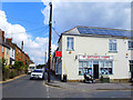
1
Bridport: postbox № DT6 102, Fulbrooks Lane
A George VI-reign postbox, of a design more usually found mounted on a pole, but set into a brick pillar and emptied finally at 4pm on weekdays and at noon on Saturdays.
Image: © Chris Downer
Taken: 12 Sep 2009
0.04 miles
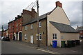
2
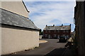
New houses behind what was the Boot Inn, North Allington
New houses behind what was the Boot Inn, 124 New Allington on the left and Boot Cottage with 122 North Allington on the right. The Boot Inn was closed by Palmers in Aug 2007 and subsequently it, the skittle alley and garages behind were converted into residential buildings.
Image: © John Stephen
Taken: 24 Jun 2015
0.05 miles
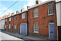
3
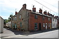
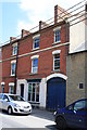
116 - 122 North Allington
Part of a Grade II listed terrace 106 - 122. The corner house No 122 appears to have the same paint scheme as "Boot Cottage" fronting onto the alley. 124 out of picture to the left was The Boot Inn.
Image: © John Stephen
Taken: 24 Jun 2015
0.06 miles
4
The former Boot Inn, 124 North Allington, Bridport
Formerly "The Boot Inn". The brewery (Palmers) closed the pub in Aug 2007 and in 2008 were granted planning permission to convert it into residential accommodation along with redeveloping the skittle alley and outbuildings attached. Reason for closure given as the change in social patterns, introduction of the smoking ban and competition from other pubs in North Allington.
Image: © John Stephen
Taken: 3 Sep 2015
0.06 miles
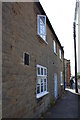
5
106 - 116 North Allington
All Grade II listed. 106 has a carriage arch and a wooden plaque by the door reading "106 Ye Auld Acquaintance 1796". In the 1895 Bridport Directory it was listed under George Pearce beer retailer. Was "The Auld Acquaintance" then the name of the pub?
Image: © John Stephen
Taken: 24 Jun 2015
0.07 miles
6
124 North Allington, The Boot Inn
Formerly The Boot Inn. It was closed by Palmers in Aug 2007 and subsequently it, the skittle alley and garages behind were converted into residential buildings.
Image: © John Stephen
Taken: 24 Jun 2015
0.07 miles
7
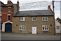
The former Boot Inn,124 North Allington, Bridport
Formerly "The Boot Inn". The brewery (Palmers) closed the pub in Aug 2007 and in 2008 were granted planning permission to convert it into residential accommodation along with redeveloping the skittle alley and outbuildings attached. Reason for closure given as the change in social patterns, introduction of the smoking ban and competition from other pubs in North Allington (all bar one now closed).
Image: © John Stephen
Taken: 3 Sep 2015
0.07 miles
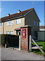
8
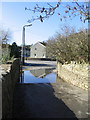
Flooded bridge over the River Brit
Looking rather like a ford, this is just a big puddle next to the small bridge over the Brit near St. Swithin's Road.
Image: © Stephen Williams
Taken: 6 Mar 2007
0.07 miles
9
126 & 128 North Allington
No 126 was a grocer's in 1895
Image: © John Stephen
Taken: 24 Jun 2015
0.07 miles