IMAGES TAKEN NEAR TO
West Allington, BRIDPORT, DT6 5BL
Introduction
This page details the photographs taken nearby to West Allington, DT6 5BL by members of the Geograph project.
The Geograph project started in 2005 with the aim of publishing, organising and preserving representative images for every square kilometre of Great Britain, Ireland and the Isle of Man.

There are currently over 7.5m images from over14,400 individuals and you can help contribute to the project by visiting https://www.geograph.org.uk
Image Map
Images are licensed for reuse under creativecommons.org/licenses/by-sa/2.0
Notes
- Clicking on the map will re-center to the selected point.
- The higher the marker number, the further away the image location is from the centre of the postcode.
Image Listing (295 Images Found)
Images are licensed for reuse under creativecommons.org/licenses/by-sa/2.0
Image
Details
Distance
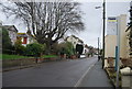
1
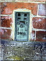
Flush bracket serial number 2119 on house in West Allington Road
Ordnance Survey flush bracket benchmark described on the Bench Mark Database at http://www.bench-marks.org.uk/bm10119
Image: © Roger Templeman
Taken: 21 Sep 2010
0.02 miles
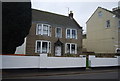
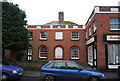
2
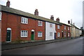
15-21 West Allington
Nos 15 & 17 Grade II listed C18, Colour washed brick, Pitched slate roof, coped gable ends, (particularly high at east end). Contemporary red brick stack,2 storeys. Band at eaves cornice. Parapet. 2 ranges of sashes with glazing bars. 2 6-panel doors.No 15 contemporary bow shopfront with glazing bars.
No 19/21 Grade II listed, C18 Red brick, pitched slate roof, coped gable end,red brick stack,2 storeys. 1 range of sashes with glazing bars. Planked double doors with ornamental iron cresting to carriage entrance marked "The Old Inn".
Image: © John Stephen
Taken: 12 Oct 2015
0.02 miles
3
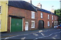
19-25 West Allington
No 19/21 C18. Red brick, pitched slate roof, coped gable end, red brick stack, 2 storeys. 1 range of sashes with glazing bars. Planked double doors with ornamental iron cresting to carriage entrance marked "The Old Inn". C19 part-glazed door.
Nos 23 & 25 Grade II Late C18. Red brick. 2 storeys. Sashes with glazing bars, 1 on ground floor tripartite. 3 centred arched yard entry. Round headed doorway. Right hand end of front has shop front with 2 bowed windows with glazing bars. 23 with the round topped carriage arch is "The Old Bakery".
Image: © John Stephen
Taken: 12 Oct 2015
0.02 miles
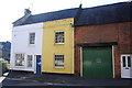
4
Terraced houses, West Allington
Grade II listed. http://www.britishlistedbuildings.co.uk/en-403212-43-57-bridport
Image: © N Chadwick
Taken: 31 Dec 2011
0.02 miles
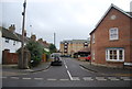
7
The former Plymouth Inn, 59 West Allington
Grade II listed early 19C. Was The Plymouth Inn until planning permission granted to Palmers Brewery to convert pub and outbuildings behind into dwellings in 2000.
Image: © John Stephen
Taken: 12 Oct 2015
0.03 miles
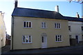
8
25, West Allington
Grade II* listed. http://www.britishlistedbuildings.co.uk/en-403209-27-and-29-bridport
Image: © N Chadwick
Taken: 31 Dec 2011
0.03 miles
9

Ordnance Survey Flush Bracket 2119
This can be found on the wall of a house in West Allington Road.
For more detail see : http://www.bench-marks.org.uk/bm10119
Image: © Peter Wood
Taken: 28 Mar 2014
0.03 miles