IMAGES TAKEN NEAR TO
Coronation Road, BRIDPORT, DT6 5AS
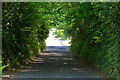
Introduction
This page details the photographs taken nearby to Coronation Road, DT6 5AS by members of the Geograph project.
The Geograph project started in 2005 with the aim of publishing, organising and preserving representative images for every square kilometre of Great Britain, Ireland and the Isle of Man.

There are currently over 7.5m images from over14,400 individuals and you can help contribute to the project by visiting https://www.geograph.org.uk
Image Map
Images are licensed for reuse under creativecommons.org/licenses/by-sa/2.0
Notes
- Clicking on the map will re-center to the selected point.
- The higher the marker number, the further away the image location is from the centre of the postcode.
Image Listing (112 Images Found)
Images are licensed for reuse under creativecommons.org/licenses/by-sa/2.0
Image
Details
Distance
1
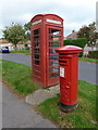
Bridport: postbox № DT6 65 and phone, Alexandra Road
These two red objects serve the suburb of Skilling and stand on the grass verge of Alexandra Road. The George VI-reign postbox is emptied at 4pm on weekdays and at noon on Saturdays.
Image: © Chris Downer
Taken: 10 Oct 2011
0.07 miles
2
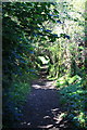
Dark Lane, Bridport.
Runs from Broad Lane down the boundary between Vearse Farm and Skilling Estate.
Image: © John Stephen
Taken: 22 May 2012
0.10 miles
3
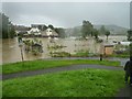
Rivers Simene and Brit floodwaters and submerged allotments at Skilling
Image: © Maurice D Budden
Taken: 7 Jul 2012
0.12 miles
4
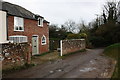
The Gatehouse at the junction of Skilling Lane and Dark Lane
Image: © Roger Templeman
Taken: 23 Feb 2011
0.14 miles
5
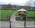
St. Mary's Playing Fields, Bridport
Entrance to St. Mary's playing field, Bridport. Skilling estate is visible in the background.
Image: © Stephen Williams
Taken: 25 Feb 2007
0.14 miles
6
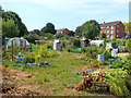
Allotments between Princess Road and the River Brit
Image: © Gary Rogers
Taken: 11 Jul 2018
0.14 miles
7
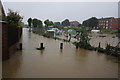
Flooded allotments
The River Simene has flooded the allotments below Skilling, whilst the Brit has flooded the St Mary's playing field beyond the end of the submerged footpath.
Image: © John Stephen
Taken: 7 Jul 2012
0.15 miles
8
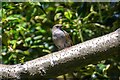
Bridport : Dunnock
A dunnock on the branch off Skilling Hill Road.
Image: © Lewis Clarke
Taken: 26 May 2020
0.15 miles
9
Bridport : Skilling Hill Road
Looking along Skilling Hill Road.
Image: © Lewis Clarke
Taken: 26 May 2020
0.15 miles
10
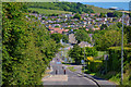
Bridport : Skilling Hill Road
Looking along Skilling Hill Road.
Image: © Lewis Clarke
Taken: 26 May 2020
0.16 miles