IMAGES TAKEN NEAR TO
Howard Close, BRIDPORT, DT6 4SR
Introduction
This page details the photographs taken nearby to Howard Close, DT6 4SR by members of the Geograph project.
The Geograph project started in 2005 with the aim of publishing, organising and preserving representative images for every square kilometre of Great Britain, Ireland and the Isle of Man.

There are currently over 7.5m images from over14,400 individuals and you can help contribute to the project by visiting https://www.geograph.org.uk
Image Map (Loading...)


Getting Data...Please wait
Leaflet Map data © OpenStreetMap
Images are licensed for reuse under creativecommons.org/licenses/by-sa/2.0
Notes
- Clicking on the map will re-center to the selected point.
- The higher the marker number, the further away the image location is from the centre of the postcode.
Image Listing (27 Images Found)
Images are licensed for reuse under creativecommons.org/licenses/by-sa/2.0
Image
Details
Distance
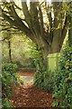
1
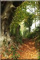
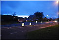
Monarch's Way from Lower Walditch Lane
The Way turns up footpath W5 6 by this beech tree, heading towards the A35.
Image: © Derek Harper
Taken: 1 Nov 2017
0.04 miles
2
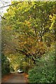
Lower Walditch Lane
Autumn colours along the lane to Bridport. The Monarch's Way emerges onto the lane by the large beech, as shown in Image], and follows the lane past the parked car.
Image: © Derek Harper
Taken: 1 Nov 2017
0.05 miles
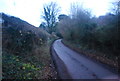
3
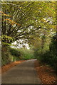
Lower Walditch Lane
The Monarch's Way has followed this lane from some 800 metres, but turns left by the beech tree as shown in Image
Image: © Derek Harper
Taken: 1 Nov 2017
0.05 miles
4
Monarch's Way at Lower Walditch Lane
A reverse view of Image], with the last few metres of footpath W5 6 before it meets the lane, which is also shown in Image] and Image
Image: © Derek Harper
Taken: 1 Nov 2017
0.05 miles
6
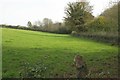
Field by Lower Walditch Lane
Looking left from where Image] was taken on the Monarch's Way.
Image: © Derek Harper
Taken: 1 Nov 2017
0.09 miles
7
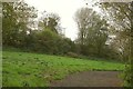
Field by Lower Walditch Lane
On the other side of the lane from Image The woodland hides strip lynchets http://www.pastscape.org.uk/hob.aspx?hob_id=450173&sort=2&rational=m&recordsperpage=10&maplat=50.73236795&maplong=-2.73619693&mapisa=250&mapist=os&mapilo=-2.7362&mapila=50.7324&mapiloe=w&mapilan=n&mapios=SY480928&mapigrn=92850&mapigre=348050&mapipc= .
Image: © Derek Harper
Taken: 1 Nov 2017
0.09 miles
9
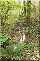
Stream by Lower Walditch Lane
A tributary of the Asker, seen looking right from the stretch of lane shown in Image
Image: © Derek Harper
Taken: 1 Nov 2017
0.10 miles