IMAGES TAKEN NEAR TO
Burton Bradstock, BRIDPORT, DT6 4QG
Introduction
This page details the photographs taken nearby to DT6 4QG by members of the Geograph project.
The Geograph project started in 2005 with the aim of publishing, organising and preserving representative images for every square kilometre of Great Britain, Ireland and the Isle of Man.

There are currently over 7.5m images from over14,400 individuals and you can help contribute to the project by visiting https://www.geograph.org.uk
Image Map
Images are licensed for reuse under creativecommons.org/licenses/by-sa/2.0
Notes
- Clicking on the map will re-center to the selected point.
- The higher the marker number, the further away the image location is from the centre of the postcode.
Image Listing (186 Images Found)
Images are licensed for reuse under creativecommons.org/licenses/by-sa/2.0
Image
Details
Distance
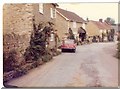
1
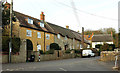
Listed cottages, Burton Bradstock
On the left is Shadrack https://www.historicengland.org.uk/listing/the-list/list-entry/1288509, spelt Shadrach on maps. In the middle is Porthkerry https://www.historicengland.org.uk/listing/the-list/list-entry/1214511 , and beyond them is Shadrack Farmhouse https://www.historicengland.org.uk/listing/the-list/list-entry/1214510 ; the three listings imply that all three once formed the same farmhouse. Number 21, facing down the lane, is also named as Shadrack on the listing https://www.historicengland.org.uk/listing/the-list/list-entry/1214508 , which seems confusing.
Image: © Derek Harper
Taken: 1 Nov 2017
0.03 miles
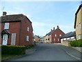
2
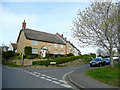
New cottages in Burton Bradstock
At the junction of Shiptons Lane, left, and Annings Lane.
Image: © Jonathan Billinger
Taken: 28 Apr 2010
0.04 miles
3
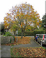
Path and trees, Annings Lane, Burton Bradstock
The lane meets Shadrach on the north side of the village.
Image: © Derek Harper
Taken: 1 Nov 2017
0.04 miles
4
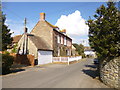
Burton Bradstock, Girt House
C18 house on Shadrach; listed by English Heritage: http://www.imagesofengland.org.uk/Details/Default.aspx?id=399338&mode=adv
Image: © Mike Faherty
Taken: 19 Mar 2013
0.05 miles
6
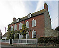
Girt House, Burton Bradstock
The listed house https://www.historicengland.org.uk/listing/the-list/list-entry/1214514 with its Venetian window is shown from the other direction in Image
Image: © Derek Harper
Taken: 1 Nov 2017
0.06 miles
8
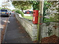
Burton Bradstock: postbox № DT6 87, Annings Lane
This Elizabeth II-reign postbox is strapped to a telegraph pole and is emptied finally at 4:30pm on weekdays and at 8am on Saturdays.
Image: © Chris Downer
Taken: 10 Oct 2011
0.07 miles
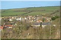
9
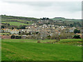
Burton Bradstock
Sheltered below the high coastal cliffs, in the valley of the River Bride. However, later development has crept up the hill beyond to more exposed positions.
Image: © Robin Webster
Taken: 26 Nov 2011
0.08 miles
10
Howarth Close, Burton Bradstock
Early 21st century housing north of Anning's Lane.
Image: © Jonathan Billinger
Taken: 28 Apr 2010
0.08 miles