IMAGES TAKEN NEAR TO
Burton Bradstock, BRIDPORT, DT6 4QE
Introduction
This page details the photographs taken nearby to DT6 4QE by members of the Geograph project.
The Geograph project started in 2005 with the aim of publishing, organising and preserving representative images for every square kilometre of Great Britain, Ireland and the Isle of Man.

There are currently over 7.5m images from over14,400 individuals and you can help contribute to the project by visiting https://www.geograph.org.uk
Image Map
Images are licensed for reuse under creativecommons.org/licenses/by-sa/2.0
Notes
- Clicking on the map will re-center to the selected point.
- The higher the marker number, the further away the image location is from the centre of the postcode.
Image Listing (210 Images Found)
Images are licensed for reuse under creativecommons.org/licenses/by-sa/2.0
Image
Details
Distance
1

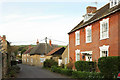
Middle Street, Burton Bradstock
The two cottages on this of the junction with Grove Road are listed. First is number 32 https://www.historicengland.org.uk/listing/the-list/list-entry/1213874 , then Jasmine Cottage https://www.historicengland.org.uk/listing/the-list/list-entry/1214379 (see also Image]). Also listed is The Red House, the brick house down the lane https://www.historicengland.org.uk/listing/the-list/list-entry/1288869 .
Image: © Derek Harper
Taken: 1 Nov 2017
0.02 miles
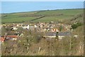
2
Burton Bradstock
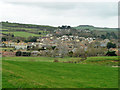
Sheltered below the high coastal cliffs, in the valley of the River Bride. However, later development has crept up the hill beyond to more exposed positions.
Image: © Robin Webster
Taken: 26 Nov 2011
0.02 miles
3
Middle Street, Burton Bradstock
A reevrse view of Image On the right is The Red House https://www.historicengland.org.uk/listing/the-list/list-entry/1288869 . At the junction with Grove Road is Jasmine Cottage https://www.historicengland.org.uk/listing/the-list/list-entry/1214379 , also shown in Image], and beyond that is number 32 https://www.historicengland.org.uk/listing/the-list/list-entry/1213874 ,
Image: © Derek Harper
Taken: 1 Nov 2017
0.03 miles
4
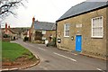
Burton Bradstock: Library
Building was the former Wesleyan Methodist Chapel (dated 1825).
Image: © Mr Eugene Birchall
Taken: 21 Mar 2010
0.03 miles
6

Direction Sign ? Signpost in Burton Bradstock
Located at the northwest end of the Y junction of the B3157 High Street and Church Street in Burton Bradstock parish. 3 arms and annulus finial. See also https://www.geograph.org.uk/photo/6681538.
Milestone Society National ID: DO_SY4889B
Image: © M Faherty
Taken: 19 Mar 2013
0.03 miles
7

Burton Bradstock, Shadrach/Shadrack
The OS map shows this road as "Shadrach", but the road name on the plate attached to the wall behind the blue car says "Shadrack".
Image: © David Dixon
Taken: 9 Sep 2022
0.04 miles
9
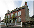
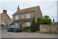
Girt House, Burton Bradstock
The listed house https://www.historicengland.org.uk/listing/the-list/list-entry/1214514 with its Venetian window is shown from the other direction in Image
Image: © Derek Harper
Taken: 1 Nov 2017
0.04 miles
10
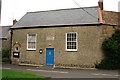
Burton Bradstock Library
This building was converted from a Methodist Chapel to a library in 1972. Before that the village was served by a mobile library service.
Image: © Tony Atkin
Taken: 14 Aug 2009
0.04 miles