IMAGES TAKEN NEAR TO
Icen Lane, BRIDPORT, DT6 4PW
Introduction
This page details the photographs taken nearby to Icen Lane, DT6 4PW by members of the Geograph project.
The Geograph project started in 2005 with the aim of publishing, organising and preserving representative images for every square kilometre of Great Britain, Ireland and the Isle of Man.

There are currently over 7.5m images from over14,400 individuals and you can help contribute to the project by visiting https://www.geograph.org.uk
Image Map (Loading...)


Getting Data...Please wait
Leaflet Map data © OpenStreetMap
Images are licensed for reuse under creativecommons.org/licenses/by-sa/2.0
Notes
- Clicking on the map will re-center to the selected point.
- The higher the marker number, the further away the image location is from the centre of the postcode.
Image Listing (8 Images Found)
Images are licensed for reuse under creativecommons.org/licenses/by-sa/2.0
Image
Details
Distance
2
Towards St Luke's Farm
Looking right from where Image] was taken.
Image: © Derek Harper
Taken: 1 Nov 2017
0.10 miles
3
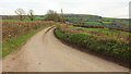
Icen Lane
Image: © Derek Harper
Taken: 1 Nov 2017
0.17 miles
4
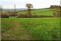
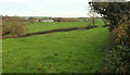
Fields near Higher Sturthill Farm
The track continues the line of Icen Lane, which bends east behind the camera.
Image: © Derek Harper
Taken: 1 Nov 2017
0.18 miles
5

Cattle near Higher Sturthill Farm
Looking left from where Image] was taken.
Image: © Derek Harper
Taken: 1 Nov 2017
0.21 miles
6
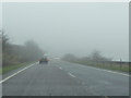
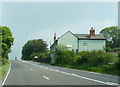
West Dorset : The A35 in Fog
The A35 is prone to fog and here it is on a pretty miserable day in Dorset.
Image: © Lewis Clarke
Taken: 21 Feb 2011
0.22 miles
7
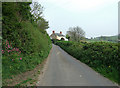
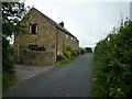
Cottage near Vinney Cross
This cottage stands close to the busy main A35 trunk road, at its junction with the minor road that heads east from Shipton Gorge.
Image: © Mike Searle
Taken: 27 Apr 2007
0.23 miles