IMAGES TAKEN NEAR TO
Annings Lane, BRIDPORT, DT6 4NG
Introduction
This page details the photographs taken nearby to Annings Lane, DT6 4NG by members of the Geograph project.
The Geograph project started in 2005 with the aim of publishing, organising and preserving representative images for every square kilometre of Great Britain, Ireland and the Isle of Man.

There are currently over 7.5m images from over14,400 individuals and you can help contribute to the project by visiting https://www.geograph.org.uk
Image Map (Loading...)


Getting Data...Please wait
Leaflet Map data © OpenStreetMap
Images are licensed for reuse under creativecommons.org/licenses/by-sa/2.0
Notes
- Clicking on the map will re-center to the selected point.
- The higher the marker number, the further away the image location is from the centre of the postcode.
Image Listing (30 Images Found)
Images are licensed for reuse under creativecommons.org/licenses/by-sa/2.0
Image
Details
Distance
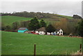
3
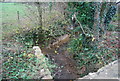
Small stream by Annings Lane
A tributary of the River Bride.
Image: © N Chadwick
Taken: 29 Dec 2011
0.10 miles
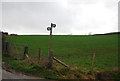
8
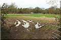
Field by the Bride
A view through a wet gateway from Bredy Road. the narrow field is very irregular in shape, being bounded on the far side by a very sinuous River Bride, and at it western end by a tributary that is almost as wiggly.
Image: © Derek Harper
Taken: 1 Nov 2017
0.16 miles