IMAGES TAKEN NEAR TO
Uplands, BRIDPORT, DT6 4LE
Introduction
This page details the photographs taken nearby to Uplands, DT6 4LE by members of the Geograph project.
The Geograph project started in 2005 with the aim of publishing, organising and preserving representative images for every square kilometre of Great Britain, Ireland and the Isle of Man.

There are currently over 7.5m images from over14,400 individuals and you can help contribute to the project by visiting https://www.geograph.org.uk
Image Map
Images are licensed for reuse under creativecommons.org/licenses/by-sa/2.0
Notes
- Clicking on the map will re-center to the selected point.
- The higher the marker number, the further away the image location is from the centre of the postcode.
Image Listing (101 Images Found)
Images are licensed for reuse under creativecommons.org/licenses/by-sa/2.0
Image
Details
Distance

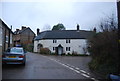
3
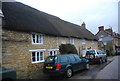
Little Thatch
A row of Grade II listed cottages. http://www.britishlistedbuildings.co.uk/en-398504-little-thatch-bothenhampton
Image: © N Chadwick
Taken: 1 Jan 2012
0.08 miles
4
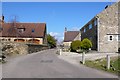
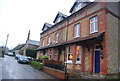
Walditch
View along the main street running through the village.
Image: © Nigel Mykura
Taken: 29 Mar 2009
0.09 miles
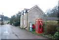
7

Walditch: postbox № DT6 16 and phone
The village postbox stands between a traditional red phone box and a Bothenhampton & Walditch parish noticeboard. The postbox is emptied at 4pm on weekdays and at noon on Saturdays.
Image: © Chris Downer
Taken: 10 Oct 2011
0.10 miles
8

Lower Walditch Lane
The lane crosses a tributary of the Asker.
Image: © Derek Harper
Taken: 1 Nov 2017
0.10 miles